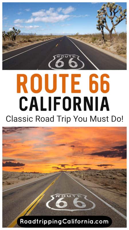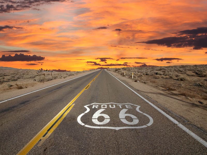
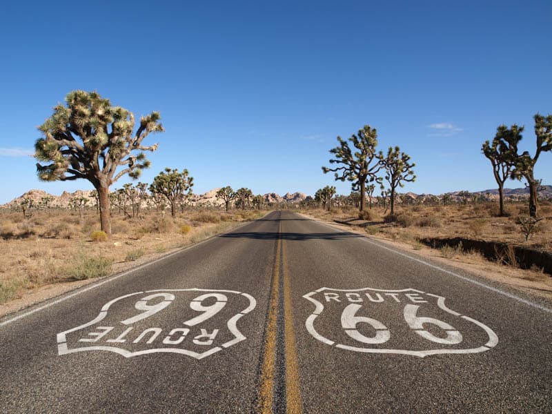
Considering a road trip along Route 66 in California? The California section of Route 66 runs through magnificent desert terrain and exciting urban landscapes, making for a fabulous road trip.
US Route 66 is a bucket-list road trip for many travelers. Immortalized in songs, movies, and books, the road is both historic and romantic. John Steinbeck called it the Migrant Road or the Mother Road.
Leading to California, the promised land, the road represented hope for migrants moving west.
The road used to end in Los Angeles, but today’s full Mother Road route between Chicago and Santa Monica is just short of 2,300 miles.
With hundreds of attractions and numerous towns and cities along the way, it takes a good amount of time to do justice to the full route.
Some links on this page may be affiliate links. If you click an affiliate link and make a purchase, we may receive a small commission, at no extra cost to you. For more details, refer to our disclosure.
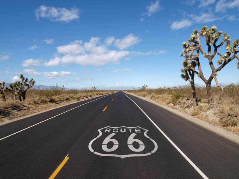
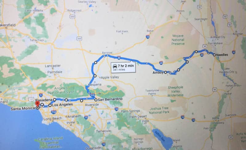
The California portion of Route 66, between Needles, on the Arizona-California border, and Santa Monica, on the Southern California Coast, is less than 350 miles: ideal if you want to experience some of the historic route in a short amount of time.
Although the route is not very long, it does feature several kitschy roadside attractions and classic Americana for which Route 66 is known!
We’ve described a road trip that starts in Needles and ends in Santa Monica, but of course you can do the trip in reverse as well. We just think it’s exciting to end at the western terminus of the full route and pose for a photo by the End of the Trail sign!
TABLE OF CONTENTS
Driving Route 66 through California: Road Trip Tips
Getting to the AZ-CA Border
California Route 66 Road Trip Itinerary at a Glance
Day 1 of California Route 66 Road Trip: Needles to Barstow
Day 2 of Route 66 Road Trip through California: Barstow to San Bernadino
Day 3 of Route 66 in California: San Bernadino to Pasadena
Day 4 of Route 66 in California Road Trip: Pasadena to Santa Monica
Driving Route 66 Through California: Road Trip Tips
Before we get into the Route 66 road trip itinerary for California, here are some tips for an enjoyable trip!
The Best Time to Do the California Route 66 Road Trip
We suggest driving Route 66 through California any time between October and April.
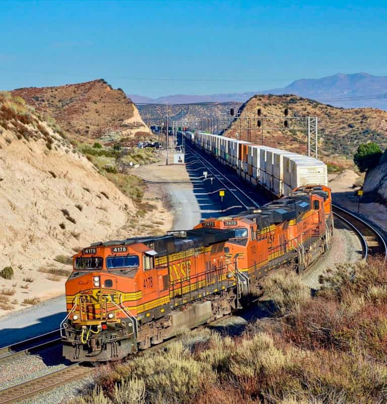
A good part of the route is through the California desert, where winter highs generally tend to be in the 60-70 degree range, and spring and fall highs in the 70-80 degree range. At these temperatures, it is comfortable to explore outdoors in the desert.
In spring and fall, you will have longer daylight hours, making it possible to see and do more in the course of a day if you so choose. The desert can be flush with wildflowers come spring, making for great photo ops.
Winter can be a wonderful time in the desert, with beautiful sunsets. But it is cold early and late in the day, so pack jackets, hats, scarves, and gloves if you plan to explore at those times.
Summer can be extremely hot in the desert portion of this route, making it dangerous to explore outside for any length of time. Triple degree daytime highs are pretty routine!
If you do the route in the summer, plan on staying inside your air-conditioned vehicle for the desert portion of the route, only getting out for quick photo stops.
Closer to the coast, the climate is more temperate, making weather a non-factor, but fall through spring is still a great time to pick for this Route 66 road trip, for lower crowds at popular attractions, and lower prices on accommodations.
Download maps and Brochures Prior to your road trip
Cellphone reception may be iffy to non-existent along the desert portion of Route 66 in California.
Download all the maps and brochures and directions you need for the trip before you set out. You can also print hard copies and carry them in a folder.
Route 66 is a historic route and regular maps may not show the route fully or in adequate detail.
Signage can also be spotty. If you want to make sure you stay on the route, invest in a guide like this one, available on Amazon. It’s for the full route, but it’s not expensive and it’s a very handy companion on the drive.
We’ve invested in a couple of gadgets that have proved immensely helpful on road trips and hikes in wilderness areas: GPS smartwatches and a backup communication device in case we need help when we don’t have cell coverage. Check them out:
The Garmin Fenix 6 is a premium model GPS watch, with all the functionality you could ask for in terms of mapping, GPS, music, and monitoring.
Buy it on REI | Buy it on Amazon
The Garmin Instinct smartwatch is a more affordable option, and you can buy it on REI or Amazon. It features GPS, heart rate monitoring, and a 3-axis compass. The construction is solid and it has a good battery life.
With a satellite subscription, the InReach Mini allows you to send and receive texts when there is no cell phone reception. It weighs only 3.5oz, and has tracking and SOS capabilities as well.
Buy it on REI | Buy it on Amazon
If you plan to explore the desert portion of the trip with detours, such as into the Mojave National Preserve, we recommend you have a GPS device, compass, and satellite communication capability.
Rent the right vehicle for your California Deserts Road Trip
You can do this California Route 66 trip itinerary in a regular sedan. The road is fully paved, except perhaps for short detours you might take in the desert to get to attractions just off the route.
If you plan to explore the Mojave National Preserve on the way, a high-clearance 4WD vehicle will make driving the dirt roads easier.
If you plan to rent a car for your Route 66 road trip, check out Discover Cars. They scour multiple providers to get the best price and find you a rental with the lowest one-way rental surcharge if there is one.
If you enjoy touring in an RV, the Route 66 road trip through is a great RVing opportunity!
There are desert areas to the north and south of US 40 you can explore if you have more time and you plan to travel in an RV or enjoy tent camping: the Mojave National Preserve to the north of US 40, and the Mojave Trails National Monument, south of US 40, feature majestic desert landscapes, including tall sand dunes and Joshua trees.
If you don’t own an RV but would like to rent one for your Route 66 road trip through California, check out Outdoorsy to find the perfect vehicle for your trip!
Route 66 is a super popular motorcycling route, so if you enjoy road trips on a motorbike, that’s an option as well! When we drove the route in the spring, there were numerous groups of bikers out enjoying the historic route on their bikes.
Other Things to Keep in Mind
Drinking Water: Make sure you have an adequate supply of drinking water loaded in your car.
Especially if you plan to hike in the desert, you need to make sure you stay well hydrated.
Although there are little towns along the desert part of the route, you want to make sure you have enough in case your car breaks down in the middle of nowhere.
Food and Snacks: Carry plenty of non-perishable snacks, and bring a cooler for perishable food.
Again, while you will want to try out roadside diners, you should have enough food for a couple of days in your car.
This is especially true if you have dietary restrictions or special needs: your food choices along the desert portion will be limited.
Gas: There are gas stations all along the route, but on the desert portion, it is safer to start out with a full tank, and fill up when you see gas stations along the way so you never run low.
On the desert portion of the route, services are spaced farther apart and tend to be minimal.
Cash: Carry a little bit of cash, just in case a museum or attraction along the route does not accept credit cards.
We always take cash in bills and a roll of quarters on every road trip.
Sun Protection and Other Essentials: You will be traveling through the desert for a part of the route.
Sun protection and a first aid kit are must-haves. Wear closed-toed sturdy shoes if you plan to hike.
Getting to the AZ-CA Border
If you plan to drive just the California portion of the route from east to west, Vegas is the nearest large city from which to arrive at the Arizona-California border.
Vegas has an international airport, car rentals are easy to obtain, and the drive, along US 95 S, will take you about one hour and 40 minutes in normal traffic.
Plan to arrive in Vegas the day before, so you can head out early the next morning.
While you will be spoiled for choice on where to stay in Vegas, we love the smoke-free suites at the Vdara Hotel & Spa in the City Center complex. We’ve also stayed at the Hilton Lake Las Vegas Resort & Spa in Henderson.
If you plan to drive the California section of Route 66 one way from west to east, Vegas is a convenient place from which to fly out after you drop off your rental car.
California Route 66 Road Trip Itinerary at a Glance
Here is a quick look at the itinerary for the Route 66 road trip in California. Continue reading for a day-by-day detailed route description, with suggestions for top sights and activities along the way, best places to stay, and places to eat.
| Days 1-3 | To-From |
| Day 1 | Drive to AZ-CA border from Vegas; Border to Barstow |
| Day 2 | Barstow to San Bernadino |
| Day 3 | San Bernadino to Pasadena |
| Day 4 | Pasadena to Santa Monica |
Day 1 of Route 66 Road Trip through California: Needles to Barstow
Driving Distance and Time: 177 miles, about 3 hours and 45 minutes
Today you will drive through the Mojave Desert, past ghost towns and classic Route 66 attractions.
We haven’t listed every single thing you can see on this stretch of road on this itinerary.
Instead, we’ve highlighted the attractions and places that warrant a stop in our opinion. If you have the time, you can certainly explore more!
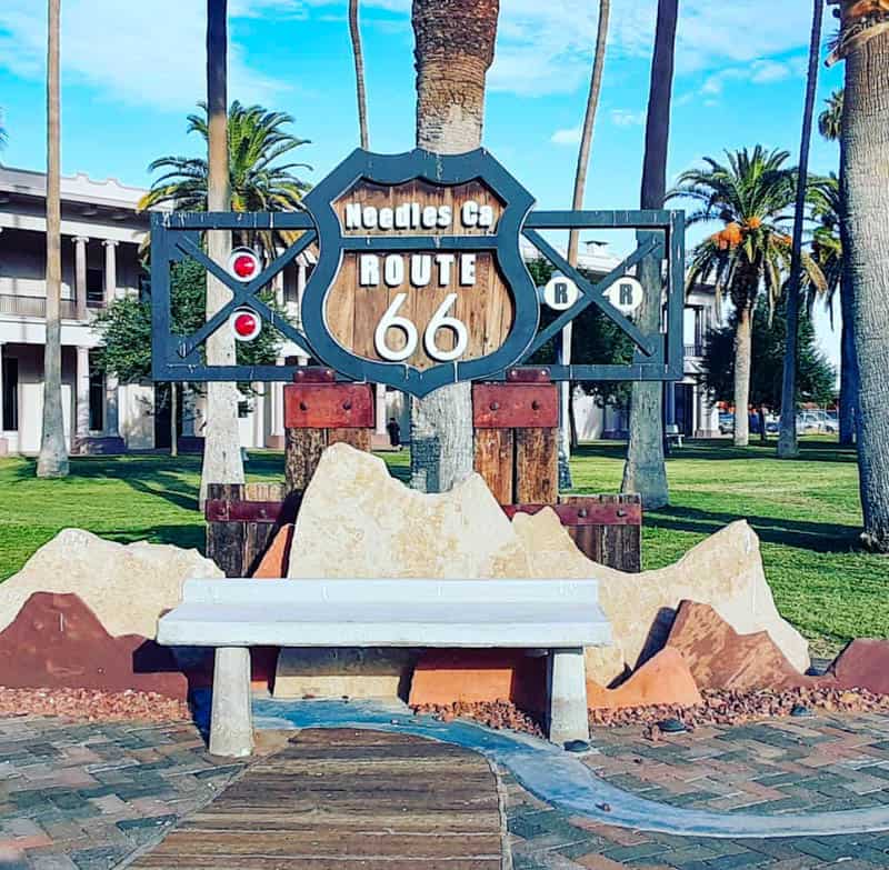
Stop at Needles
Needles, just inside the California border with Arizona, gets its name from the sharp pointy peaks of the pinnacles in the Mohave Mountains to the south of the town.
There are Route 66 signs you can follow in Needles, to take in sights like the photogenic Route 66 Motel.
Also make sure to stop by the El Garces Hotel, a freight and passenger depot that opened in 1908 and is reminiscent of a Greek temple.
The luxury establishment was managed by the famous Fred Harvey Company, known for its management of many hotels along the old railroads. The building was saved from being destroyed by a local group, with plans to renovate.
The hotel is listed on the National Register of Historic Places.
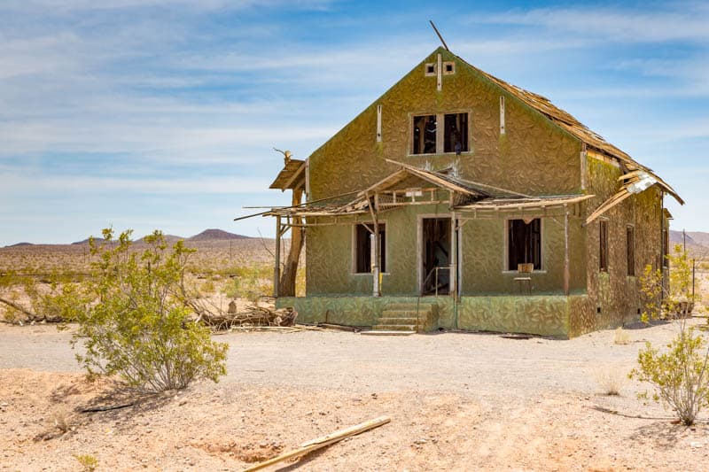
Drive through the Ghost Towns of Goffs and Essex
After you leave Needles you’ll pass through a section of the route that contains a number of ghost towns: Goffs, Essex, and Danby.
Little remains of the towns, but it’s interesting to drive through to take in what’s left of the chapter of California history, and they offer good photo ops.
These little towns saw their heyday during the days of the railroad and Route 66.
In Goffs, you can see the remains of an old general store, a schoolhouse from the early 1900s that’s been renovated and now houses a museum, and mining relics.
Essex, on the old National Trails Highway, was once a thriving little town, but now lies almost completely abandoned. It’s known for not having TV reception until 1977.
Danby was established in 1883 as a water stop station, and you can see the remains of a few old buildings.
View the Graffiti Corridor in Chambless
Continuing west along the National Trails Highway, you will come to Amboy.
Along the way, you can’t miss the Graffiti Corridor at Chambless: it goes on for miles and consists of spray-painted rocks and other objects previous visitors have left behind as a mark of their visit.
It’s a tradition to leave something here, so, if you like, you can bring something to record your visit too!
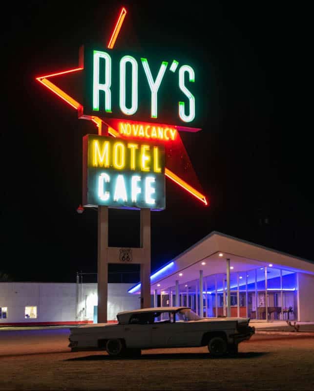
Stop in Amboy
Amboy is one of the must-stop spots on the California stretch of historic Route 66.
Established in 1883, the town was once a major stop along the railroad and Route 66, but withered away after the opening of US 40.
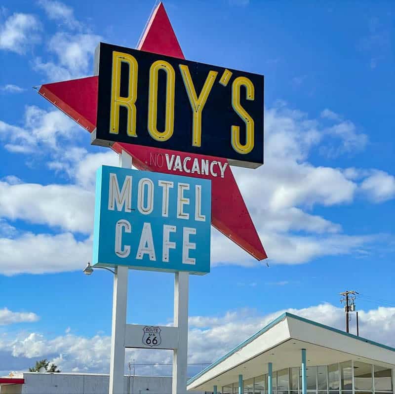
Roy’s Motel and Cafe opened in 1938, and quickly became successful as the only place you could get gas, food, and lodging along that section of the route.
The famous sign, a popular photo stop on Route 66, was put in place only in 1959. The cafe is famous for its Googie architecture.
Roy’s was renovated in the 2000s, but at the time of writing, only the gift store is operational. A few other buildings still survive in the town.
Stop at the Amboy Crater
Just a little bit further along the National Trails Highway, take the road to the Amboy Crater, a National Natural Landmark.
About 1,500 feet across and 250 feet high, the extinct cinder cone is located on one of the youngest volcanic fields in the USA. It is said to erupted about 10,000 years ago.
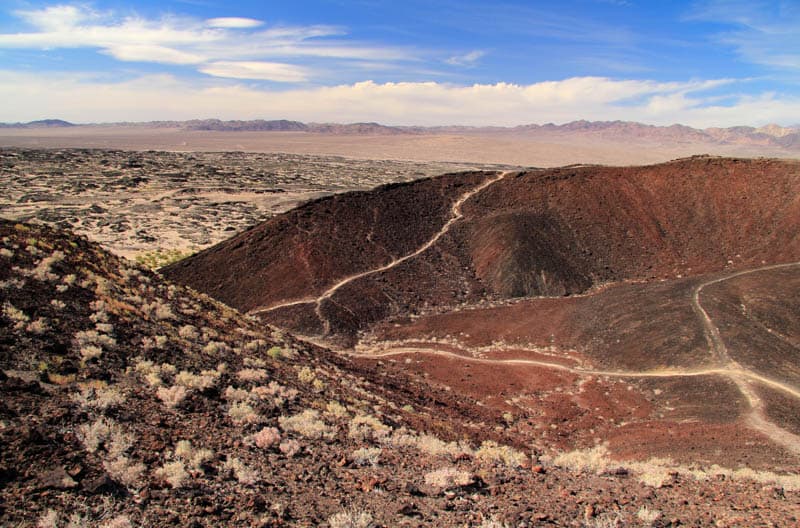
Amboy Crater is known for its symmetry and stark beauty. You can hike up and into the crater, and also walk along its rim, a total hike length of about 3 miles. The views from the top are spectacular.
If you don’t want to climb to the top, you can snap photos of the crater from the viewing area, or walk the flat trail to the base of the crater, about one mile each way, to see it up close.
Springtime sees beautiful wildflowers here.
There are picnic tables and restrooms.
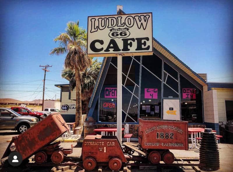
Stop at Ludlow
If you continue along the National Trails Highway, you will pass the ghost town of Bagdad, where you will only find the cemetery, and Siberia, of which nothing remains, before driving on to Ludlow.
Established when the Atlantic & Pacific Railroad built a station here in the 1880s, Ludlow boomed due to nearby mining operations.
When the mining petered out, Ludlow deteriorated, but with the establishment of Route 66, it recouped some of its fortunes.
But eventually, when US Highway 40 opened, Ludlow declined for good, and today, it’s a ghost town.
Stop by the ruins of the Murphy Bros. General Store and the Old Ludlow Cafe. The new Ludlow Cafe serves classic diner food if you want to stop for a meal here.
You can also see the sleepers of the T&T Railroad, the post office, the old Richfield Service Station, and the old Filling Station.
Stop in Daggett
After you leave Ludlow, continue along the National Trails Highway towards Barstow.
Along the way, you will pass Newberry Springs, where you can snap a photo of the Bagdad Cafe and the Henning Motel. You’ll also find the historic Cliff House here: it was a cafe and gas station, and also offered cabins.
Next, you’ll pass Daggett, known for its many Route 66 attractions: Russian House, with its Bochka roof, Kelley’s Restaurant, with its arrow-shaped sign, the Mugwumps Service Station, and the California Agricultural Inspection Station: its older version featured in the 1940 movie The Grapes of Wrath.
Do a Detour to Calico Ghost Town
About seven miles north of Daggett is Calico Ghost Town, founded in 1881 as a silver mining town and abandoned toward the end of the 19th century after silver lost its value. Today it is a State Historical Landmark, and a regional park.
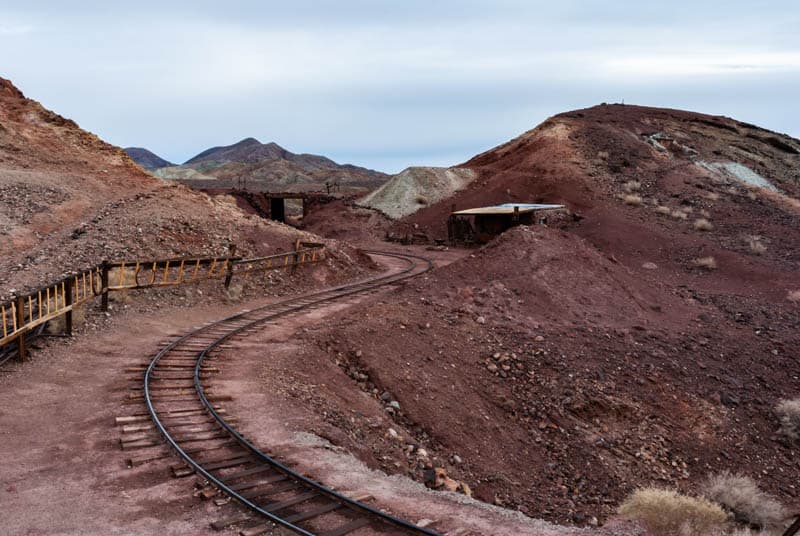
Here you can see many of the town’s buildings restored to look like they did in the 1880s, along with shopping and dining.
Tour Maggie Mine, one of the original silver mines, pan for gold, and ride a historic railroad. The local museum houses artifacts and old documents. The park also offers hiking and biking.
Calico is a fun detour, if you’ve made good time during the day and arrive before the attractions close.
Sleep in Barstow
Barstow has a rich history and numerous Route 66 attractions. Originally inhabited by Native Americans, the area became a mining center in the late 1800s. Both silver and borax were mined here.
Unlike other towns in the area, Barstow did not disappear once mining stopped, because two modern highways: I-15, and I-40, converge in Barstow, making it an important stop on the transportation route across the Mojave Desert.
It’s a good place to stop for the night, with lodging, shopping, and dining options.
Where to Stay in Barstow
Ayres Hotel is located off I-15, with lots of eateries within walking distance. The property features an indoor pool and hot tub. Rooms are spacious and comfortably furnished. Book on booking.com | Book on hotels.com
Hampton Inn and Suites Barstow is also located right off the highway. It has an outdoor pool and fitness room. Air-conditioned rooms are well-reviewed, with comfortable beds. Each room comes with a refrigerator and a microwave. Book on booking.com | Book on hotels.com
Comfort Suites Barstow is located near I-15. The property features an outdoor pool and hot tub. Suites are spacious and have a sitting area and a comfortable bed. Each room has a refrigerator and a microwave. Book on booking.com | Book on hotels.com
Day 2 of Route 66 Road Trip Through California: Barstow to San Bernadino
Driving Distance and Time: 80.1 miles, about 1 hour and 30 minutes
Today you have a shorter distance to cover, but the places along this stretch of the route have lots to see, so you will need more time. From motels and inns to museums and cafes, this is Route 66 at its historic best!
Explore Route 66 Attractions in Barstow
The center of Barstow is home to a host of old Route 66 motels, some of which are still in operation.
If you drive east to west along Main Street, you can see many of them, from the Best Motel (which used to be the Imperial 400), to the Sands Motel, the Cactus Motel, the Sage Motel, and El Rancho, with its stunning signage.
Many of the motels feature very cool neon signs!
Also on Main Street are the former Denny’s Diner, now Jenny’s Mexican Grill Steak & Mariscos, the Village Cafe, with its green neon sign, and Barstow Garage, a century-old building that is now a church.
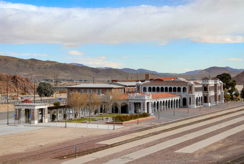
The Harvey House Railroad Depot is part of the Fred Harvey group of hotels and restaurants. The present structure was built in the early 1900s and features beautiful architecture.
Listed in the National Register of Historic Places, the depot houses the Route 66 Mother Road Museum, with photos and artifacts you can browse. It also houses the Western America Railroad Museum.
Don’t miss the plethora of old signs at Tom’s Certified Welding & Machine Shop.
You will find the shop along US Highway 58. The Mojave River Valley Museum showcases the history and culture of the Mojave River Valley.
At the Desert Discovery Center, you can view the second-largest meteorite found in the USA.
Drive Through Lenwood and Hodge
Continue along the National Trails Highway through the little towns of Lenwood and Hodge.
In Lenwood, check out the abandoned Dunes Motel, and in Hodge, the Two Sixes sign is worth a photo stop.
At Hodge, you will also find the Hinkley Road Turnoff. Hinkley is the town from Erin Brockovich.
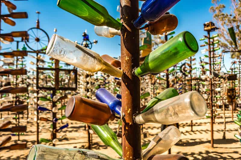
Check Out Elmer’s Bottle Tree Ranch
Next you will come to Helendale, where the must-see attraction is Elmer’s Bottle Tree Ranch, which features several dozen “trees” made of scrap metal, hung with bottles.
It is one of the most iconic sights along the California section of Route 66!
Also in Helendale, view Burden’s Store and Post Office, built in 1926, the Polly Gas Station sign with the green parrot, and the lone Joshua tree where once stood the Potapov’s Service Station.
Drive through Oro Grande and Over the Bridge
Oro Grande is a small town which has a few attractions you can drive past, or stop briefly for photos.
The Iron Hog Saloon started life as a stage stop in the 1890s and went through several incarnations along the way.
The Mohawk Service Station and La Delta Service Station and Auto Court are other interesting sights here.
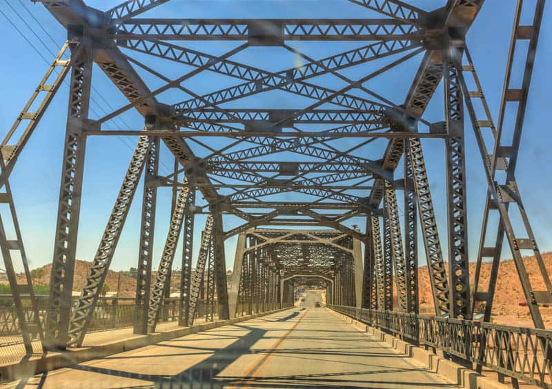
The Oro Grande Bridge over the Mohave River is a Baltimore truss bridge from 1930, and driving over it will take you to Victorville, your next stop along Route 66 in California.
See the Sights in Victorville
Victorville styles itself the “Key City of the High Desert.”
Possibly the most famous stop here is Emma Jean’s Café and Truck Stop. The cafe was opened in 1947 by the Hollands, and Emma Jean worked as a waitress at the cafe until her husband bought it in 1979 and named it after her.
The cafe is still operational, and the burgers are highly rated, so be sure to stop and check them out!
The California Route 66 Museum is located in Victorville. The museum features a number of classics from the past, such as a Ford T from the early 1900s and a diner from the 1950s. There is a gift shop you can browse for souvenirs.
Snap a photo of the Old Town Route 66 gateway sign, and the attractive Green Spot Motel.
You can see a couple other historic inns and motels in the town, but most have disappeared.
Drive Over the Cajon Pass
At Cajon Pass, Route 66 leaves the Mojave Desert for the Los Angeles area.
The mountain pass has been used since the time of the Native Americans that inhabited the area, thousands of years ago.
In the late 1880s, the Atlantic & Pacific Railroad connected San Bernadino and Barstow via the Cajon Pass, and Route 66 later traversed the pass as well. Today’s I-15 goes through Cajon Pass as well.
Summit Inn, built in 1952, was destroyed by a fire in 2016, and only the sign remains. Other historic sites, such as Meekers Cafe and camp Cajon, have not survived time.
The scenery along the pass is beautiful, with the San Gabriel Mountains on one side and the San Bernadino Mountains on the other. The San Andreas Fault runs along the pass, as does the Pacific Crest Trail between Canada and Mexico.
Sleep in San Bernadino
San Bernadino was inhabited by Native Americans for thousands of years until the Spanish arrived in the early 1800s. They established a mission in San Bernadino and later the San Bernadino Ranch.
Both the railroad and Route 66 came to San Bernadino making it an important stop on the route across the country. Eventually, with the building of I-15, the city lost some of its luster as fewer travelers felt the need to stop here.
The city is home to numerous Route 66 attractions.
With plenty of options for lodging, dining, and shopping, San Bernadino is a great place to spend the night.
Where to Stay in San Bernadino
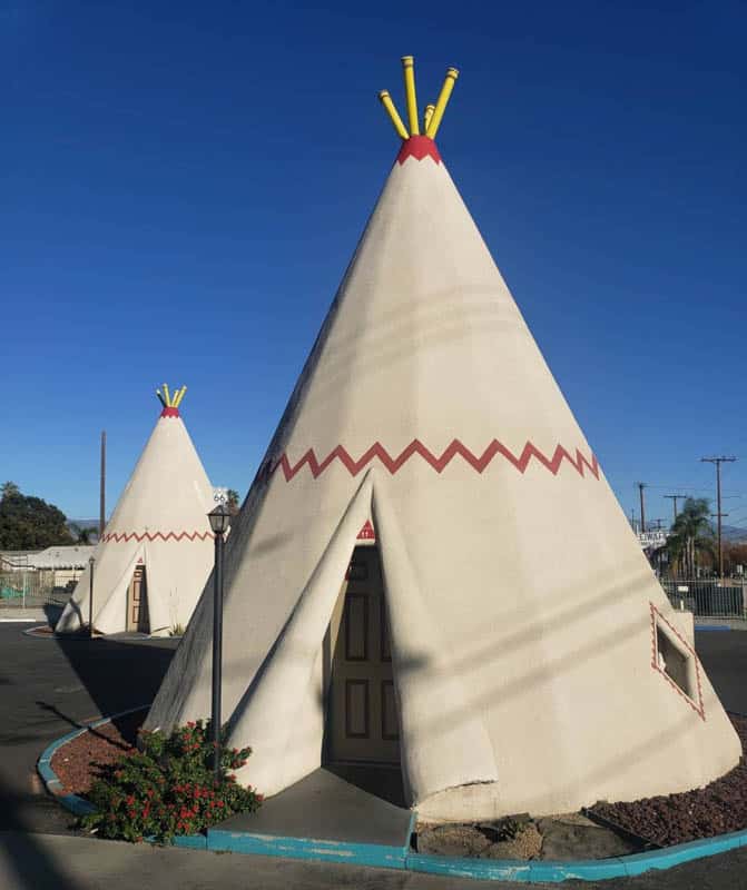
The Wigwam Motel is your opportunity to stay at a historic Route 66 lodging option! Individual rooms shaped like teepees are offered, some with a sitting area. There is an outdoor pool. Each room has a refrigerator and cable TV. Book on booking.com
Residence Inn by Marriott San Bernadino features suites with full kitchens. There is an indoor pool on the property. Suites are spacious and comfortably furnished. Book on booking.com | Book on hotels.com
Hilton Garden Inn San Bernadino offers spacious, comfortably furnished non-smoking rooms, each with a refrigerator and a microwave. There is a pool on the property, and an onsite restaurant. Book on booking.com | Book on hotels.com
Day 3 of Route 66 Road Trip Through California: San Bernadino to Pasadena
Driving Distance and Time: 64.6 miles, about 1 hour and 40 minutes
Today you will explore San Bernadino and then drive through a string of small towns on your way to Pasadena.
On this itinerary, you will just have time to drive around some of the towns to check out the old motels and service stations and other landmarks and take photos.
Driving Distance and Time:
Tour the San Bernadino Route 66 Sites
San Bernadino has several classic Route 66 motels and landmarks.
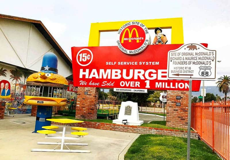
Here you will find the original McDonald’s Restaurant, started by brothers Richard and Maurice in 1940. In 1948, they honed the fast food model, with a limited menu of burgers, soda, and milkshakes. Today the structure is a museum you can tour!
The Santa Fe Railway Station and Depot is another iconic landmark in San Bernadino. The current structure, in Mission Revival style, dates from the early 1900s. It still functions as a railway station.
If you didn’t stay in the Wigwam Motel, definitely visit it! This was the seventh and final wigwam village built by Frank Redford. Only three survive, two of them along Route 66.
The San Bernadino village opened in 1950. After Redford’s death, they fell into decline until they wee restored and re-opened in 2002.
Drive around and tour the various motels and service stations: the San Bernadino Motel and the Terrace Motel, Old Wilshire Service Station (it has a cool sculpture-like canopy!), the Astro Motel, the Oasis Motel, the Dream Inn, and several others. Many still have cool signs you can photograph.
Check out the Giant Orange in Fontana
The Giant Orange used to be a fruit stand, one of several that sold juice to thirsty travelers along Route 66.
The brightly-colored juice station is 6.5 feet tall and was owned by the Bonos. It was closed in the 1950s, and today stands in the parking lot of Bono’s Restaurant and Deli, also a Route 66 landmark.
Also in town, you will find some old Route 66 motels: the Rose Motel, the Dragon Motel, the 40 Winks Motel, and the Cheryo Motel, among others. Some of the signs are cool enough to warrant a quick photo stop.
Photograph the Service Station in Rancho Cucamonga
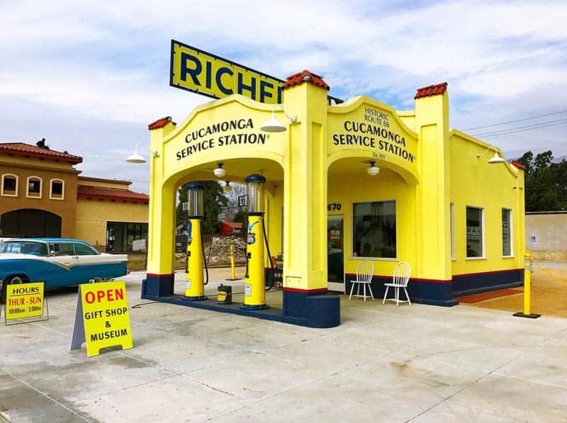
Rancho Cucamonga has one of the cutest service stations you will see along the route. The bright yellow structure was built in 1915, and is now included in the National Register of Historic Places. It now houses a Route 66 and local history museum.
The Magic Lamp opened in 1957, on the site of an Italian restaurant. Its facade has changed, but the sign is still cute. You can still dine here!
In Rancho Cucamonga, you will also find the Thomas Winery, the oldest winery in California, established by Don Tiburcio Tapia in 1839. Today the Thomas Winery plaza houses a restaurant and a coffee shop.
Also visit Rains House, the former home of John Rains, owner of Rancho Cucamonga after Tapia. The brick home is listed in the National Register of Historic Places.
Tour Upland
Upland is the last stop on the Inland Empire portion of Route 66. Sadly, expanding urbanization has resulted in many Route 66 sites being razed, but you can still enjoy a few choice landmarks here.
Snap a photo of a rare McDonald’s, with the golden arches part of the structure. The building dates from the 1950s.
Stop by The Madonna of the Trail, dedicated in 1929. Representing the indomitable spirit of the pioneer women that helped settle the west, the statue is one of twelve monuments that stand in the states crossed by the National Old Trails Highway.
Also, don’t miss the Grove Theater, built in 1947, and the Giant Cup of Coffee along West Foothills Boulevard. They both make for great photos!
Drive through Claremont and Pomona
Pretty college towns, Claremont and Pomona each have a smattering of Route 66 sites, as well as other historic buildings. The Santa Ana Botanic Garden in Claremont is a fun visit if you enjoy gardens.
In Claremont, check out Tugboat Annie’s, which looks exactly like a tugboat. The seafood restaurant was built in the 1950s. In Pomona, snap photos of the Coates Bicycles sign and the Fox Theater, an Art Deco building from the 1930s.
If you enjoy historical sites, Pomona is home to two adobe homes built by Ygnacio Palomares, who had a vast amount of land in this area granted to him and Ricardo Vejar by the Mexican governor.
Tour la Verne and San Dimas
La Verne is home to a vintage McDonald’s building, where the golden arches are built into the structure.
Snap a photo of the classic La Paloma Restaurant sign on Foothill Boulevard. The 1966 restaurant is still in operation.
Mr. D’s Diner is another photo-worthy stop: both the structure and the sign are cool.
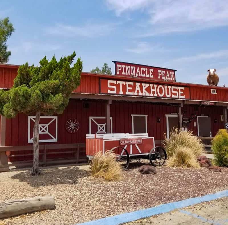
In San Dimas, you will want to stop at the Pinnacle Peak Steakhouse, to photograph the covered wagon, a classic Route 66 landmark. Reportedly, if you wear a tie to this steakhouse, it will be cut and hung from the rafters!
Sadly, we didn’t have the time to go inside to see how many are hanging from the roof!
Drive through Glendora and Azusa
In Glendora, you will find a beautiful Art Deco food mart and vintage gas station: the Food Mart at the corner of Glendora Avenue and Route 66.
The Golden Spur Restaurant sign is another popular Route 66 photo stop, and so is the sign for the Hat Pastrami, which still serves sandwiches.
In Azusa, photo spots worth a stop include the Foothill Drive-In Theater sign and the Canyon City liquor store sign. There are so many cool signs to photograph all along the route!
You won’t want to stop at every single one, but you will likely have a nice collection by the end of your trip.
Stop in Monrovia
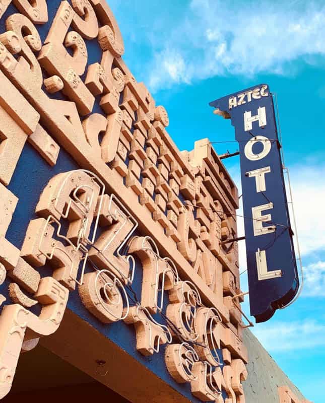
Monrovia has a number of sights worth visiting, so plan on spending a little more time here: two classic hotels, some gas stations, and another must-see McDonald’s.
The Aztec Hotel opened in 1925. It was ornate and built to showcase Mayan art and architecture concepts in modern buildings. Today it is one of a very small number of Mayan-inspired buildings in the US.
Inside, you will find Mayan murals and mosaics, in a continuation of the concept. The building is listed in the National Register of Historic Places.
Although in its heyday Monrovia boasted several motels, today only a few survive.
Other than the Aztec Hotel, the Oak Park Motel from the 1950s still stands, as does the Leven Oaks, which was built in 1911.
You can also view a few classic service stations in the town: the Flying A, with its Mission Revival style, is definitely worth a photo stop.
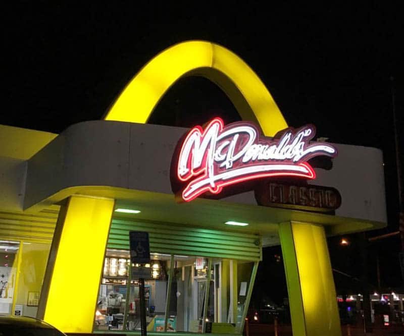
The McDonald’s on Route 66 in Monrovia features a historic logo, where the M has a strikethrough toward the bottom. It is a cool photo op!
Drive through Arcadia and Sierra Madre
Many of Arcadia’s Route 66 motels and other sites have been destroyed, but check out some of those that remain: the Art Deco building that housed the Arcadia News Journal, and the Denny’s with the windmill at the corner of Huntington Drive and Santa Anita Avenue.
Sierra Madre was not actually on Route 66, but it does have a few historic buildings worth viewing. The Sierra Madre Playhouse is housed in a building from the 1920s, and features a beautiful facade. The Hotel Shirley is from the early 1900s.
Also in Sierra Madre you will find one of the world’s largest flowering plants: a gigantic wisteria that was planted on a porch and eventually crushed the home. It now spans two properties! Visit in early spring to see it in bloom.
Sleep in Pasadena
Pasadena is one of our favorite places to visit in Southern California.
Located at the foot of the San Gabriel Mountains, the city features a wealth of gracious architecture, a lively Old Town, and numerous wonderful eateries. Of course, it is also home to the famous Rose Bowl, and a number of Route 66 attractions and landmarks.
If you haven’t visited Pasadena before, you may want to add a day to your trip just to experience the city in greater depth. Plus, you can spend a few hours at The Huntington, a world-famous complex of gardens and art.
You’ll be spoiled for choice on where to eat in Pasadena. We like La Grande Orange Cafe, True Food Kitchen (an upscale chain), and Saladang for Thai.
Where to Stay in Pasadena
Courtyard by Marriott Pasadena Old Town has a location in the heart of all the action in Old Town Pasadena. The property has an outdoor pool. Rooms are spacious and comfortably furnished. Some rooms feature a separate sitting area. Book on booking.com | Book on hotels.com
The Westin Pasadena is located a short drive from the Old Town. It features an outdoor heated pool and an onsite restaurant. Rooms are spacious and well-furnished, and each room includes a refrigerator. Book on booking.com | Book on hotels.com
The Langham Huntington is located a short drive from Old Town Pasadena. The stately old hotel features gorgeous grounds and gardens, a heated outdoor saline pool, an onsite spa, and several onsite dining options. Rooms are elegantly furnished and come with Italian marble bathrooms. Book on booking.com | Book on hotels.com
Day 4 of Road Trip on Route 66 in California: Pasadena to Santa Monica
Driving Distance and Time: 26.5 miles, about 1 hour and 10 minutes
Toady you will explore Pasadena in the morning, and head to Santa Monica thereafter to complete your road trip. There’s a lot to see and do in Pasadena, but we will stay focused on Route 66 sights for the most part.
Explore Route 66 in Pasadena
Check out the Foothill Boulevard Milestone, also called a Bancroft Marker, at the junction of Holliston Avenue and East Colorado Boulevard.
It is the only surviving mile marker (number 11) from a system implemented at the beginning of the 20th century and abandoned in only two years.
The marker is listed on the National Register of Historic Places.
The Howard Motor Company Building is built in the Churrigueresque style, a Spanish style of architecure you will also find in Balboa Park in San Diego.
The auto dealership building from 1927 is one of the most ornate structures on East Colorado Boulevard, and is also listed on the National Register of Historic Places.
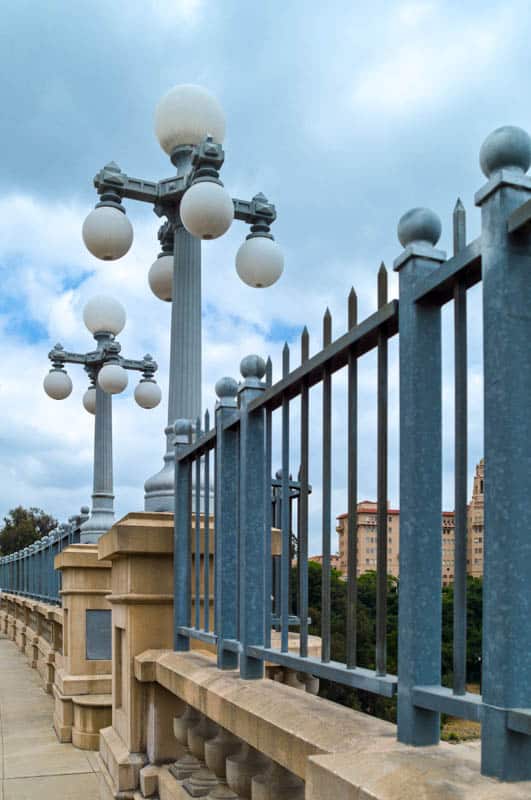
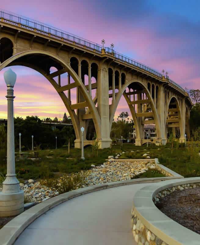
The Colorado Street Bridge, over the Arroyo Seco, was the highest concrete bridge in the world at the time it opened, in 1913. It remained a part of Route 66 until the Arroyo Seco Parkway was completed in 1940, after which it fell into disrepair.
Listed in the National Register of Historic Places, the bridge was renovated and reopened in 1993. It is a beautiful work of engineering!
The Bekins Storage Co. Roof Sign is also listed in the National Register of Historic Places.
The massive sign was designed to attract the attention of motorists passing by in their vehicles. It is the only one left of the many such signs that were popular in the first part of the 20th century.
You can see the rooftop sign on South Fair Oaks Avenue: it reads Public Storage Co.
There are a number of old motels you can drive past: the El Rancho Motel, the Pasada Motel, with its vintage neon sign, the Hi-Way Host Motel, the Astro Motel (now Knights Inn), with its Googie architecture, and La Casa Inn (now Swiss Lodge), with its gabled roof.
Visit the Gamble House, built in 1908 in the Craftsman style. Today it houses a museum, and you can tour it. Also don’t miss the Wrigley Mansion, the former home of the chewing gum magnate.
See the Rialto Theatre in South Pasadena
One of Pasadena’s few remaining ornate theaters from the early 20th century, the Rialto Theatre is decently preserved and is listed on the National Register of Historic Places.
The building features Moorish elements and has a newer Art Moderne neon marquee sign. The inside is very ornate, with crown molding and huge chandeliers. It is closed now, and supposedly haunted!
Also in Rialto, check out the Fair Oaks Pharmacy & Soda Fountain at the corner of Mission Street and fair Oaks Avenue. Step inside to admire the vintage interior and the original soda fountain.
Explore the Route 66 Sights in Los Angeles
There are numerous Route 66 landmarks in LA and it would take quite a bit of time to do justice to all of them. On this itinerary, we’ve listed a few that we think are nice to see. Certainly, if you have the time, there is a lot more to discover!
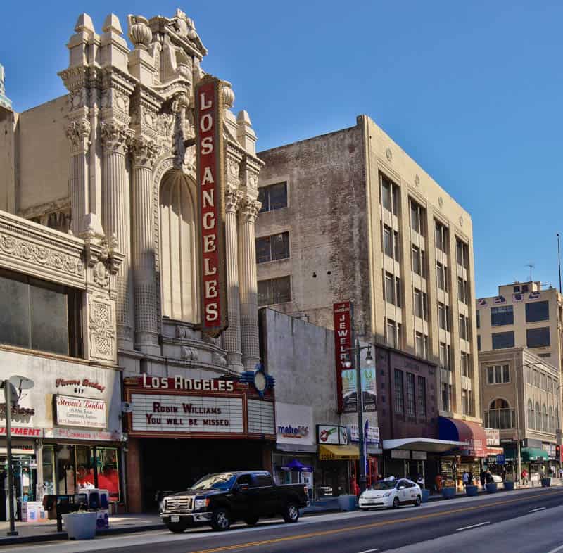
In downtown Los Angeles, you will want to visit the old terminus of Route 66 at Broadway and 7th. There is a sign showing that this was the terminus in 1926.
The Los Angeles Theatre, in the Broadway Theater and Commercial District, makes for a great photo, with its ornate facade. There are several other old theaters here as well.
Along Colorado Boulevard, you can drive by the Casa Lu-An Motel (it does not have the vintage signage though), the Cindy’s Diner sign, and the Rose Bowl Motel.
Along North Figueroa, you will find the Chicken Boy statue and a small vintage gas station that looks like a shed.
Along Sunset Boulevard, you can drive by the Paradise Motel, with its neon sign, and the Olive Motel, also with a beautiful old neon sign.
In Hollywood, check out the La Brea Hotel, and you can’t visit Hollywood and not admire the TCL Chinese Theatre, built in 1927.
See the Route 66 Sights in West Hollywood and Beverly Hills
In 1926, Route 66 was extended along Santa Monica Boulevard, from LA to Santa Monica. In West Hollywood, Mel’s Drive-In, along Sunset Boulevard, is famous for its Googie architecture.
The Art Deco Sunset Tower Hotel is listed on the National Register of Historic Places.
Barney’s Beanery was established in Berkeley in 1920, and it moved from Berkeley to West Hollywood in 1927. It was frequented by many older Hollywood actors and writers. You can still enjoy classic American fare here.
In Beverly Hills, the Union 76 Service Station makes for a great photo: it is another great example of Googie architecture along the route. Also check out the Beverly Hills Hotel, a Beverly Hills landmark that opened in 1912.
Celebrate the End of the Trail in Santa Monica!
The Santa Monica Pier is considered the current western terminus of historic Route 66. Here you can pose for a celebratory photo by the “End of the Trail” sign!
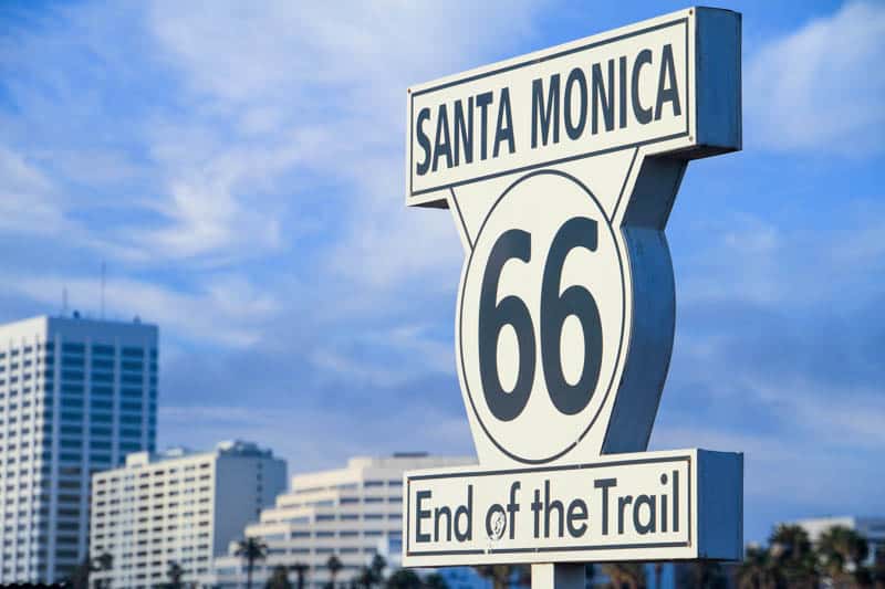
The actual endpoint is at the intersection of Lincoln Boulevard and Olympic Boulevard, a short distance from the pier, if you want to visit to mark your presence at the official western terminus.
*****
Planning to explore more of the Golden State? Check our other day-by-day itineraries for California road trips!
- Big Sur Road Trip
- California Deserts Road Trip
- Highway 395 Road Trip
- 4-Week California Road Trip
- LA to Las Vegas Road Trip
Did you find this article informative? Pin it for later reference!