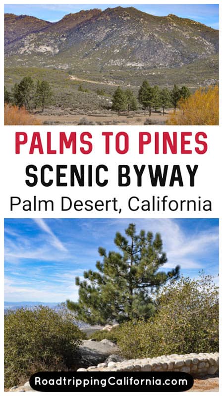
One of the most scenic driving routes in California, the Palms to Pines Scenic Byway is a must-do excursion when you visit the Greater Palm Springs area!
If you are looking for scenic drives near Palm Springs, the Palms to Pines Scenic Byway can’t be beat for the wow factor when it comes to scenery.
The Palms to Pines Highway scenic drive is one of the easiest and prettiest day trips from Palm Springs (or Palm Desert) you can do, with time to stop and hike some short trails and explore the towns and other attractions along the way.
You can also just do the drive, stopping at scenic overlooks, and make it a half-day excursion.
Whichever way you do this beautiful drive, you will love it!
Considering the Palms to Pines Scenic Byway drive? Read on to learn what to expect, plus our tips for doing the drive.
Some links on this page may be affiliate links. If you click an affiliate link and make a purchase, we may receive a small commission, at no extra cost to you. For more details, refer to our disclosure.
TABLE OF CONTENTS
What can you expect on the Palms to Pines Highway?
Essential facts about the Palms to Pines Scenic Byway
Which direction is best for the Palms to Pines Scenic Drive?
Map of the Palms to Pines Scenic Byway
Tips for Driving the Palms to Pines Scenic Byway in Southern California
What Can You Expect on the Palms to Pines Highway?
Drive from the palms on the desert floor to the pine forests at the mountain tops in under an hour, if you do not stop along the way!
This drive features stunning views all along the route, plus the opportunity to stop at different places to explore or enjoy the views.
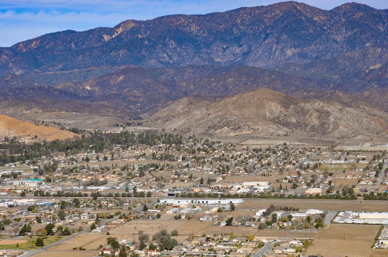
We drove the route starting in Palm Desert and ending in Banning, so that’s how we’ve described it. Catch California Highway 74 in Palm Desert to start your mini road trip.
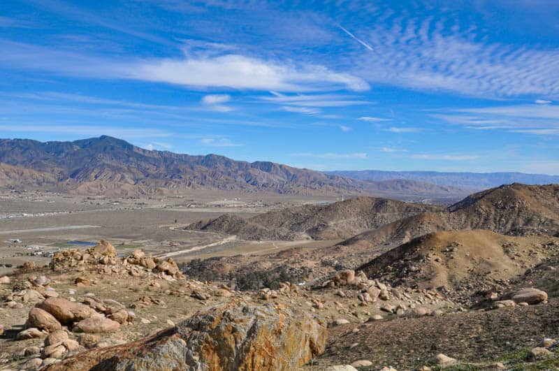
Stop at the Santa Rosa and San Jacinto National Monument Visitor Center
The Santa Rosa and San Jacinto National Monument protects more than 280,000 acres, and the Palms to Pines Scenic Byway runs along part of it.
At the Visitor Center, you can obtain maps and brochures, and speak with staff about potential activities along the route.
Walk the super short Ed Hastey Garden Trail to learn about local flora and fauna, or walk the longer Randall Henderson loop. You can walk from one mile to 2.5 miles. The trail features nice views over the valley and you may be lucky and see bighorn sheep, or a desert tortoise, or birds!
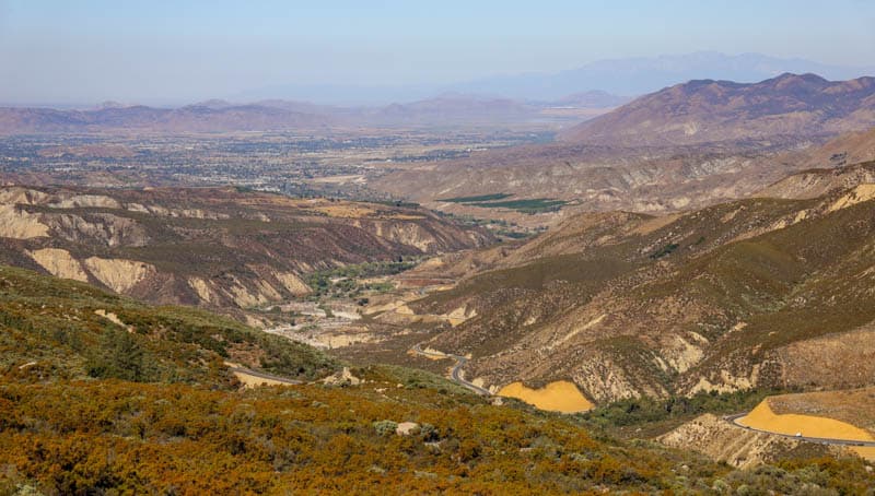
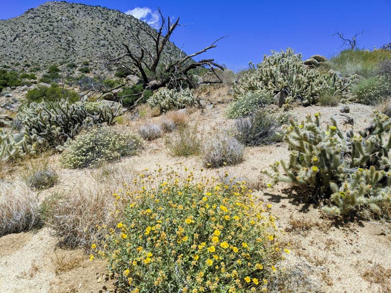
Past the Visitor Center, the road winds its way uphill via a series of switchbacks, with vistas over the desert floor and an up close view of boulder masses and ocotillos and other local flora along the slopes.
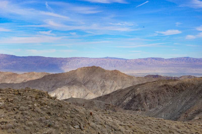
Stop at the Coachella Valley Viewpoint
This viewpoint is arguably the best vista point on the uphill portion of the drive. Many visitors to Palm Springs that are crunched for time just drive up to this vista point and back.
From the large viewing area, you can see the urban areas and the golf courses of the desert resorts spread out beneath you, along with the tans and browns of the desert hills.
There is lots of parking, so park and walk around to enjoy the view from different angles and snap lots of photos!
As you continue your drive, you will notice desert flora give way to small pinyon pines, and the rugged rocky landscape starts to get tamer.
Stop at the Cahuilla Tewanet Vista Point
Next you will drive past the small towns of Pinyon Crest and Pinyon Pines on your way to Paradise Valley.
Stop at the Cahuilla Tewanet Vista Point for great views of the mountains. The parking lot is much smaller, and there is a small loop trail you can walk.
At Paradise Valley, Highway 371 meets up with Highway 74. Paradise Valley Cafe makes for a good drink and restroom break if you need one. Keep on Highway 74.
Stop at Lake Hemet
Lake Hemet is a man-made reservoir set amidst the mountains and pine forests. It is a popular place for camping and fishing.
The scenery leading up to Lake Hemet is beautiful, with pines and other alpine vegetation. You will see small farms along with way, with cows and horses grazing in fields. It is very pastoral!
Lake Hemet offers boat rentals, so if you plan to spend the full day on the drive, you can take a boat out on the water for an hour or two. Kayaks, pontoon boats, and motor boats are available.
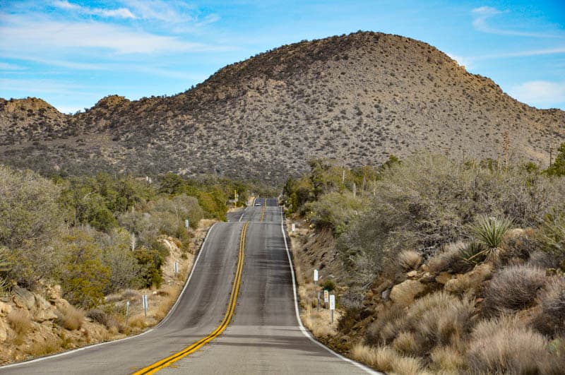
Next, you will drive on to Mountain Center, a little town with shops and a gas station if you need to fill up. Here you will take Highway 243 towards Idyllwild.
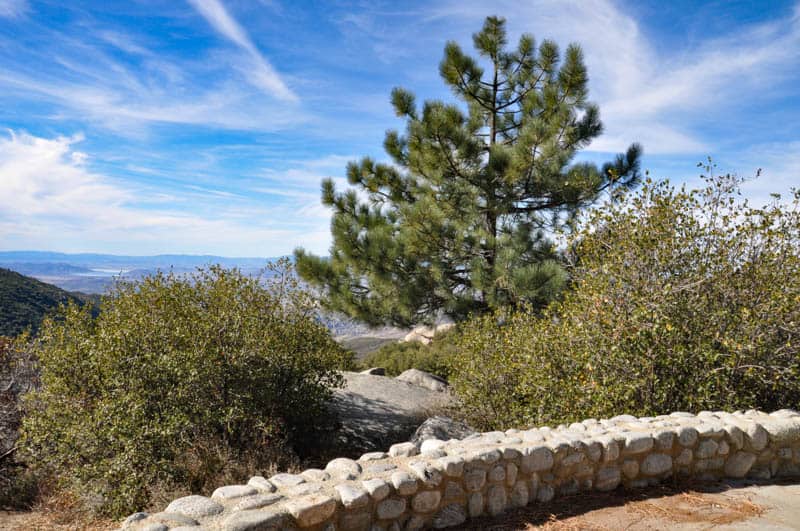
Stop at Idyllwild
Idyllwild is a charming mountain town set amidst the mountains.
It is one of the most popular day trips from San Diego or LA, and the gateway to Mount San Jacinto State Park, where you will find trails leading to the summit of the 10,834-foot mountain.
If you started early in the day, Idyllwild is the perfect place for lunch and a hike to stretch your legs. Idyllwild Bake Shop & Brew offers superb sandwiches and sweet treats, and a serene patio to sit and enjoy your meal.
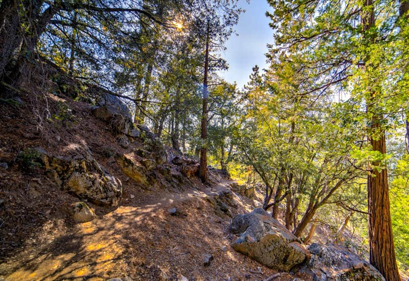
Walk off the carbs at one of the many trails in the area.
The Ernie Maxwell Scenic Trail is 2.6 miles long and offers the chance to see many species of trees, wildflowers in season, and birds. Idyllwild Nature Center offers some easy to moderate trails as well.
The town of Idyllwild has some charming one-of-a-kind stores and art galleries and makes for a pleasant wander if you do not feel like a hike into nature.
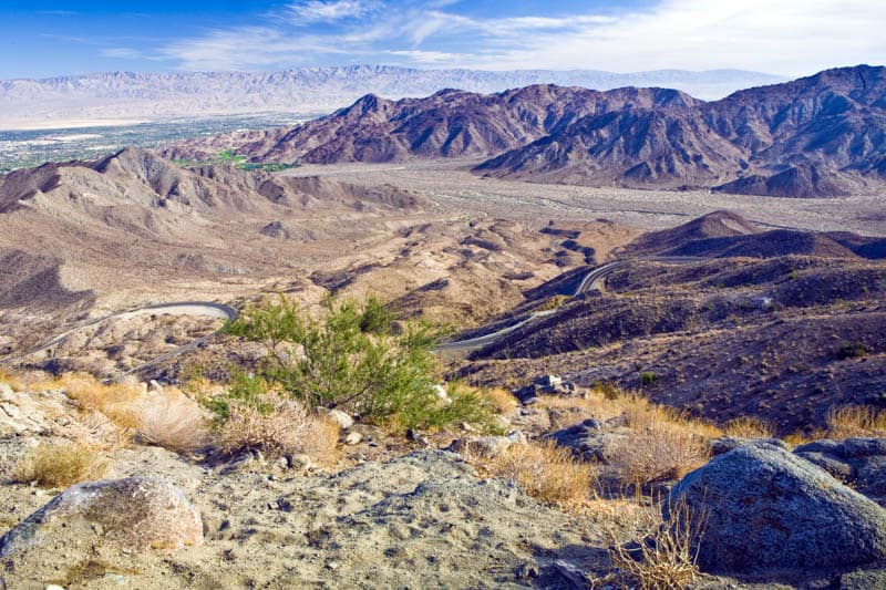
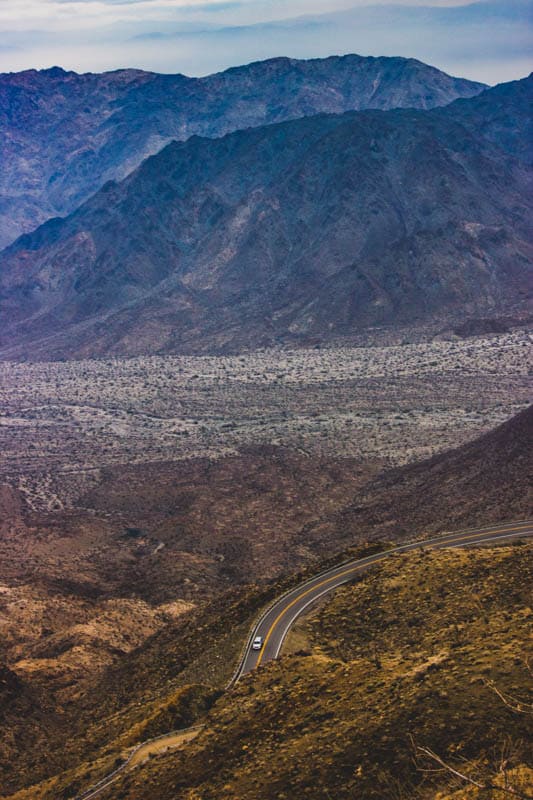
Stop at Indian Vista Scenic Overlook
As you head into the descent, Indian Vista Scenic Overlook is the major viewpoint for photos, with plenty of parking and expansive views over the valleys to the south.
The viewpoint is marked by a gigantic boulder.
Once you leave the viewpoint, the road starts to leave the forests behind, and there are more pullouts where you can stop for photos of the valleys below.
You will negotiate a series of switchbacks as the road descends back into the desert at Banning, the endpoint of your scenic drive. Here you can take the freeway back to Palm Springs or Palm Desert.
Essential Facts About the Palms to Pines Scenic Byway
The Palms to Pines Scenic Byway is 67 miles long and fully paved.
It was designated a National Forest Scenic Byway in 1993, and offers the opportunity to traverse a variety of ecosystems within a short distance.
For the bulk of its length, it is a two-lane road, with occasional widening into four lanes to allow for passing.
Note that the route is used by commuters between the coast and the desert and you may encounter traffic and drivers that are intent on getting to their destinations. It is also popular with motorcyclists in nice weather months.
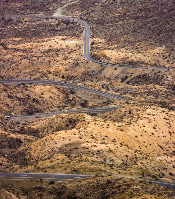
Pullouts for enjoying the views are generally on the right side of the road. There are at least two sections of the route with switchbacks as the road climbs into the mountains or descends into the desert.
Gas and food and drink are available at small towns along the route, but to be safe, start with a full tank of gas.
Which direction is best for the Palms to Pines Scenic Byway drive?
You can drive the Palms to Pine Scenic Byway either from Palm Desert (by starting at Highway 74) to Banning or from Banning to Palm Desert (by starting on Highway 243 south of Banning).
The route is beautiful in both directions, so you can choose to drive it in whichever direction appeals to you or is more convenient.
Some visitors go up and down from one start point, such as from Palm Desert to Idyllwild and back down.
If you are coming from the coast, you can also call it the Pines to Palms Scenic Byway and drive it from Idyllwild down to Palm Desert or Banning!
Map of the Palms to Pines Scenic Byway
Tips for Driving the Palms to Pines Scenic Byway
Go when there is no snow in the forecast
Snow accumulations in winter can cause road closures, plus you will need snow tires and chains for winter travel on the higher elevations of this route in poor weather conditions.
Check the weather forecast and pick a day when the weather is dry and clear. We drove the route on a good weather day in late February, and while we saw snow accumulations on the sides of the road, the road itself was dry and clear of snow.

Dry spells at the fringes of the winter months, or early spring or very late fall, will likely offer the best weather for all the ecosystems you will traverse, from desert to mountain tops. In the spring, you will see lots of wildflowers!
drive the Route during daylight hours
The Palms to Pines Scenic Byway is a road with switchbacks, and it does not have guard rails along the full length of its twisty sections.
You will want to drive the route when you have good visibility.
Avoid the route at night, especially the switchback portions.
Allow more time than you think you’ll need
Although you can drive the route in a little under two hours with no stops, the scenery along the way is beautiful so you will want to take your time. Plus, there are little towns to check out and scenic hiking trails along the way!
Allow at least four hours and plan on spending a morning or an afternoon driving the route, with a few stops along the way.
Even better, plan on making it a day trip if your schedule allows.
We did the Palms to Pines Highway as a day trip from Palm Desert and spent about eight hours, with stops at Lake Hemet to boat and Idyllwild for a couple of hikes. And lots of other photo stops along the way.
Expect Other Visitors, Especially in Season
The route is popular with visitors. Plus, commuters use the route to travel between the desert and the coast. So expect traffic on the route, and impatient commuters.
Pull over safely to let faster traffic through so you can enjoy the scenery at a slower pace.
When the weather is nice, expect to see lots of motorcyclists on the route. We even saw a bicyclist on the route up from Palm Desert!
Dress in Layers
Expect the weather at the higher elevations to be significantly cooler than on the desert floor.
When we visited in late February, it was a sunny and balmy 72 degrees in Palm Desert in the morning, and a misty and cool 55 degrees in Idyllwild in the middle of the day, with patches of snow on the sides of the road.
Dress in layers, and bring some rain gear as well, just in case. If you plan to hike, wear sturdy, closed-toed hiking shoes or boots with good traction. Trails weren’t muddy when we visited but they could be wet if you visit in the cooler months.
Bring your camera and binoculars
The scenery is gorgeous, so you will want to take lots of photos. If you like photographing birds or wildlife, but don’t want to carry a heavy lens when you are hiking, consider a digital camera with a powerful zoom.
We use a tiny camera that fits into our jacket pockets: the Panasonic Lumix DC-ZS70. It has a 30X zoom and Leica lens, and produces pictures that look pretty good.
If you enjoy bird or wildlife viewing, bring your binoculars. We use the Celestron Trailseeker: they are waterproof and work great in the low light of dawn and dusk, when you can most expect to see birds or wildlife.
*****
Planning to explore more of California? Check out some of our other articles on scenic drives!
- Artist’s Drive in Death Valley National Park
- Tioga Road through Yosemite National Park
- June Lake Loop in the Eastern Sierra
- Whitney Portal Road in Lone Pine
- Onion Valley Road in the Eastern Sierra
- 17-Mile Drive through Pebble Beach
Did you find this article informative? Pin it for later reference!
Thank you!
Now, I took this Byway on accident back maybe Dec 2nd 2020 or so.
My 16 year old and I took a wrong turn and wound up on a scenic byway, SCENIC is the key word; at 1:00 a.m. big moon no traffic, of course!
You are not even kidding about the switchbacks at night! We were not prepared! Your description was so thoughtful of the little places to stop; that although I thought i would never want to return, you blog certainly makes me think again; maybe this time. During the day!
Blessings and Peace,
Rhonda
I am so glad you made it to your destination safely! My husband and I discussed waiting for sunset at the last vista point, but decided against it because we didn’t want to be negotiating the switchbacks after dark. Definitely much better in good weather and good light!
Yes, I agree it is beautiful but not a good experiment for the night. The day is recommended in clear weather for newcomers. I too accidentally landed on the “by-way” trap. Meaning, once you go too far on the one-lane path, it is neither too wise, nor safe to try to stop and turn around if a chain of cars is following plus cars coming in the distance and you cannot really see. I had two small children with me. So, the high elevation, poor lighting, and constant winding one-lane road were a lot to take in-especially since it lasted over an hour. In addition, the vets of this path also can get impatient as I watched a few risk using the “oncoming traffic lane” and fly in front of you if they deem you are going too slow for their liking. I hope I prepared someone, as I was not.
Thanks for detailing your experience. We agree completely: we recommend doing the drive in daylight on a good weather day.