Planning a visit to Death Valley National Park? Discover the best things to do in Death Valley, from must-visit scenic overlooks to sensational hikes and drives through the magical landscapes of the park.
From hiking the golden Mesquite Flat Sand Dunes to walking across the white Badwater Salt Flat, and from gawking at the beautiful badlands at Zabriskie Point to admiring colorful mineral deposits at Artist’s Palette, there is a lot to do in Death Valley!
The dramatic desert vistas in Death Valley National Park will leave you speechless with their scale and stark beauty.
One of California’s two stunning desert national parks, Death Valley is a must on any California bucket list.
Some links on this page may be affiliate links. If you click an affiliate link and make a purchase, we may receive a small commission, at no extra cost to you. For more details, refer to our disclosure.
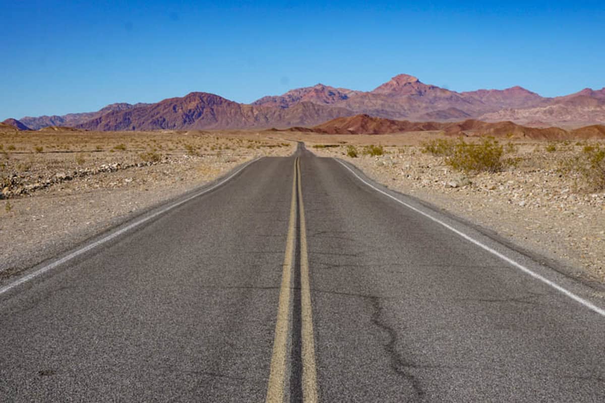
Located in southeastern California, on the California-Nevada border, Death Valley National Park is about 4.5 hours by road from Los Angeles and a two-hour drive from Las Vegas in neighboring Nevada.
Whether you plan to do a Las Vegas to Death Valley day trip, enjoy the park on an LA to Vegas road trip, or visit as part of a California desert road trip, Death Valley National Park will captivate you.
While there are many hiking trails in the park, you can have a productive visit to Death Valley National Park without a lot of hiking.
Read on to discover the most exciting things to do in Death Valley National Park: the must-visit Death Valley attractions and points of interest you will not want to miss!
Best Things to Do in Death Valley
At 3.3 million acres, Death Valley is enormous. In fact, it is the largest national park in the contiguous United States! But thankfully for the visitor strapped for time, many of the best things to do in Death Valley are not too far apart.
And when you visit this amazing park, you will be visiting the hottest, driest, and lowest national park in the country! The highest ever temperature on earth, a scorching 134 degrees Fahrenheit, was recorded in Death Valley in 1913.
The landscapes of colorful rocks and sand dunes in the park, in hues of gold, yellow, and tan are, in a word, otherworldly.
But if you think Death Valley is completely flat and arid, think again! In winter, you can see the snow-dusted peaks of the Panamint Range from many spots in the park, and there is even a waterfall at the western edge of the park.
Death Valley National Park is a stop on our epic 4-week California road trip itinerary, and on our 2-week California road trip itinerary as well.
The park’s landscapes, dark skies, spring wildflower carpets, and diverse wildlife make it worthy of any Southern California itinerary.
Excited? Let’s dive right into all the best things to do in Death Valley National Park!
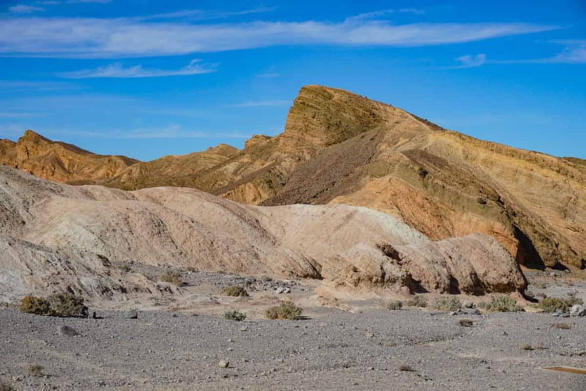
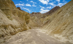
1. Marvel at the Views from Zabriskie Point
Easily accessed from California State Route 190, the main road running through Death Valley National Park, Zabriskie Point is the most famous scenic overlook in the park.
From the parking lot, a short, uphill walk leads to the viewing area. The walk is paved.
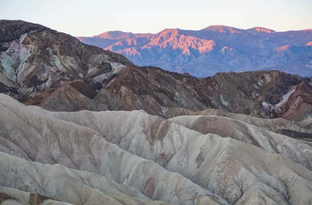
From the circular viewing area, take in the 360-degree views of the surrounding badland ridges in shades of yellow, gold, tan, and rust. And if you want to get up close, hike the 2.5-mile Badlands Loop!
Created by the forces of erosion over millions of years, the badlands form a dramatic and very unique landscape. In the distance, you can see the Panamint Mountains to the west.
While any time of day is wonderful to marvel at the views here, head to Zabriskie Point at sunrise for amazing photos. Sunsets are gorgeous too, especially when the skies change to orange and pink after the sun sets.
Do you have your National Parks Pass yet? Valid for one full year from the month of purchase, the America the Beautiful National Parks Pass costs USD 80.00 and offers admission (one vehicle or 4 persons) to over 2,000 Federal recreation sites, including national parks, national forests, and more!
Get yours online at REI now!
Pro Tip: Visiting Zabriskie Point at sunrise? Arrive early (as in when it’s still dark) to snag a prime spot. Photographers with tripods arrive here in droves at sunrise, especially in the cooler high-season months. Bring a flashlight.
Pro Tip: In winter, you’ll want to bundle up for a sunrise visit: think beanie, warm jacket, gloves, socks and shoes. It can be freezing cold at dawn!
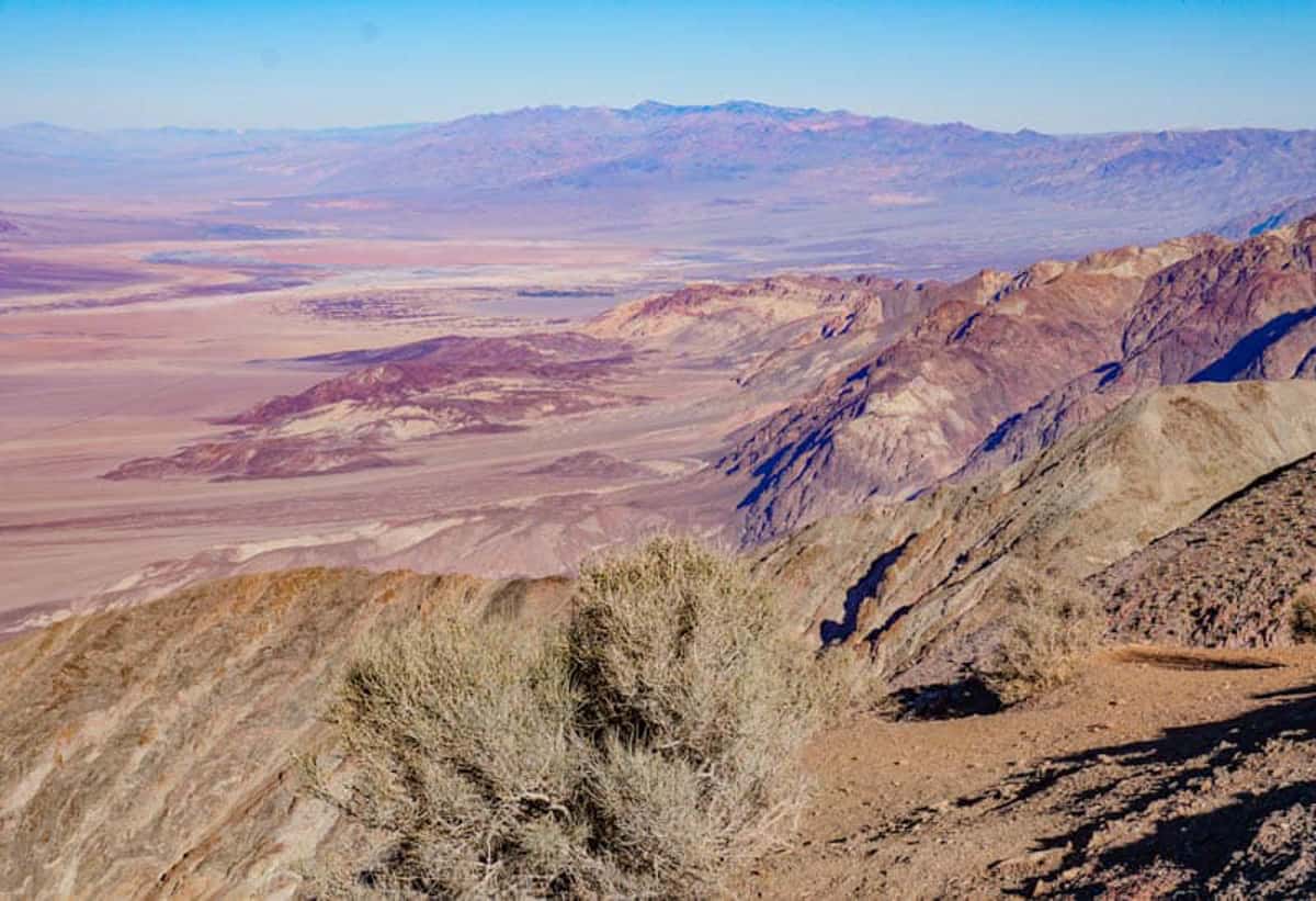
2. Admire the Panoramas from Dante’s View
At a little over 5,500 feet, Dante’s View is a scenic overlook that affords stunning panoramas over the valley: the vast salt flat of Badwater Basin below, and the Panamint Mountains in the distance.
On a really clear day, you can see both the highest and the lowest points in the contiguous USA from Dante’s View: Mount Whitney (14,505 feet) and Badwater Basin (-282 feet).
If you look closely, you can see Badwater Road snaking through the landscape below.
The road is fully paved and the final section is steep and has some hairpin bends.
Once at the top, you can either just take in the views from the area next to the parking lot, or you can walk the trail along the ridge at the top to take in the views from point along the trail!
If you are up for it, the hike along the ridge leads all the way to Mt. Perry. It’s a strenuous 8-mile round trip hike.
You have to drive about 13 miles from California SR 190 to get to the parking lot and viewpoint, but once you are at the top, you will agree that the views are worth the detour.
Visit at sunrise or sunset for photo ops, or after dark on a no-moon night for epic stargazing.
Pro tip: While the main viewing area may be a little crowded at sunset, walk along the ridge a bit and you’ll leave most of the crowds behind.
3. Walk on the Sand at Mesquite Flat Sand Dunes
Mesquite Flat Sand Dunes are not the only sand dunes in Death Valley National Park, but they are the most accessible, and therefore the most popular.
Located near Stovetop Wells, the dunes can be accessed from California SR 190, the main road through the park.
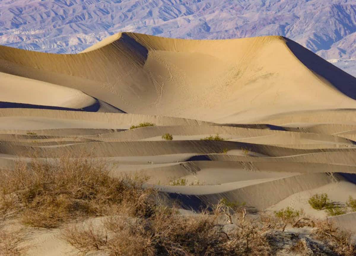
The field of golden sand dunes looks picturesque against the darker mountains rising up behind. Mesquite Flat Sand Dunes are a favorite photo spot in Death Valley National Park!
The tallest dune in the field is only 100 feet tall, but the dune field is large in size. You can walk out from the parking lot onto the sand, as far as you wish to go.
There are mesquite trees in this part of the park, and you may see birds or wildlife, especially at dawn and dusk.
You can go sand boarding at Mesquite Flat Sand Dunes, so bring your boards!
Visit early or late in the day to enjoy the most dramatic light and shadow effects on the dunes. Your photos of the dunes will be best at these times of day as well.
Pro tip: Closed-toed shoes are advised: the sand can be super hot.
Eureka Dunes, which the park states you can access in most standard vehicles, are located in the north of the park, about 45 miles from Ubehebe Crater.
The 44-mile road from the crater to the dunes is graded dirt, so I would be leery of attempting it in anything but a 4WD high clearance vehicle.
There are three other sand dune systems in the park: Ibex, Saline Valley, and Panamint Valley.
4. Admire the Salt Flats at Badwater Basin
The salt flats at Badwater Basin are yet another of Death Valley’s fantastic sights.
Home to the lowest point in North America at 282 feet below sea level, the Badwater Basin salt flats stretch on endlessly as far as the eye can see.
There’s a small super salty pool near the boardwalk, and a sign where you can pose for a photo.
Once upon a time there was a large inland lake here, but it eventually dried up, leaving the salt deposits behind.
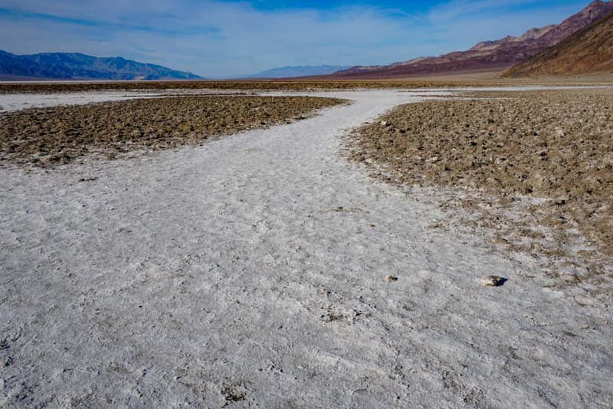
You can walk out onto the salt flat to see in person the famous salt polygons that you’ve likely seen on Instagram. For the best views, you’ll need to walk out a fair bit: about .75 mile or so each way.
Periodic rains create a thin sheet of standing water on the salt crust, and when the water dries up, the crust cracks into the polygon shapes. Isn’t that cool?
Look for Telescope Peak in the Panamint Mountains to the west: it’s over 11,000 feet above sea level for a cool contrast to where you are standing below sea level!
Sunset is a great time to photograph the salt flats, as is sunrise.
Visit early or late in the day to avoid the heat: even when we visited in December, it was very warm at Badwater Basin in the early afternoon.
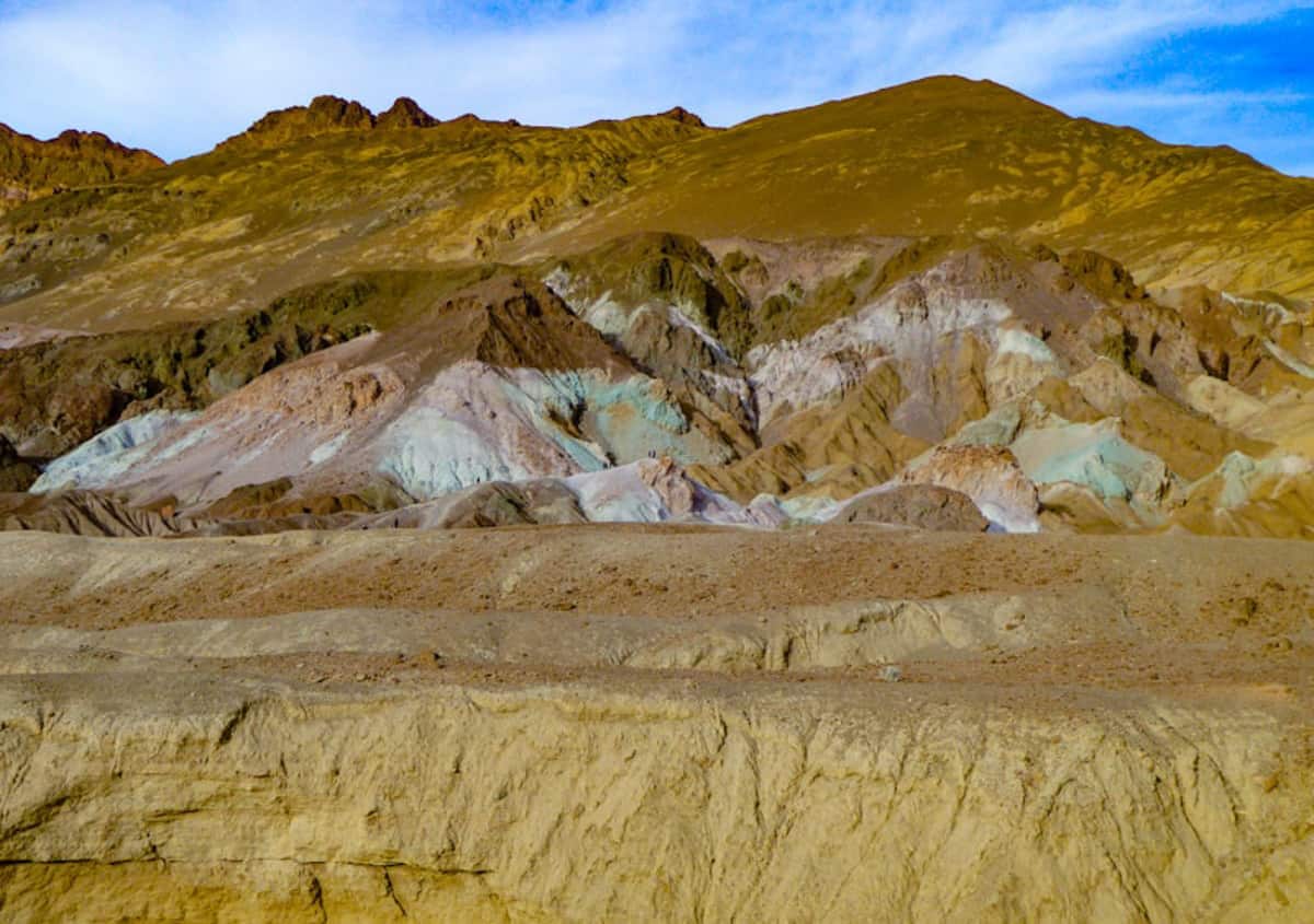
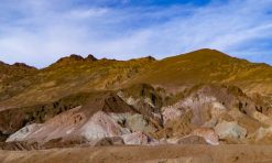
5. Do the Gorgeous Artist’s Drive
The spectacular Artist’s Drive is a 9-mile one-way loop off Badwater Road.
Winding its way through colorful canyons, Artist’s Drive is arguably the most scenic drive in Death Valley National Park.
The high point of the drive is the Artist’s Palette viewpoint, about 5 miles into the drive.
The Artist’s Palette features colorful volcanic mineral deposits in yellow, orange, rust, pink, lavender, blue, and green.
Definitely an Instagrammable spot in the park!
If you park at the official parking lot, you can get down into the wash and then climb onto the brightly-hued deposits or into the little canyons.
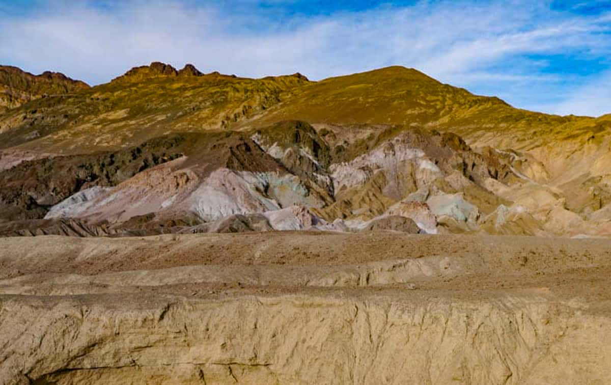
The rest of the drive is beautiful as well, and you can pull off the road in some spots to explore the hills and canyons.
The road bends and dips, and offers views of both the Black Mountains and the salt flats.
You’ll see the sign for Artist’s Drive as you drive Badwater Road. The turnoff comes up about 8.5 miles from the junction of Highway 190 and Badwater Road.
Read More
Artist’s Drive and Artist’s Palette in Death Valley
6. Check Out the Devil’s Golf Course
A vast area of jagged crystallized salt spires along Badwater Road, the Devil’s Golf Course is one of the more unique Death Valley points of interest.
The place apparently got its name because “only the devil could play golf” on such a rough course.
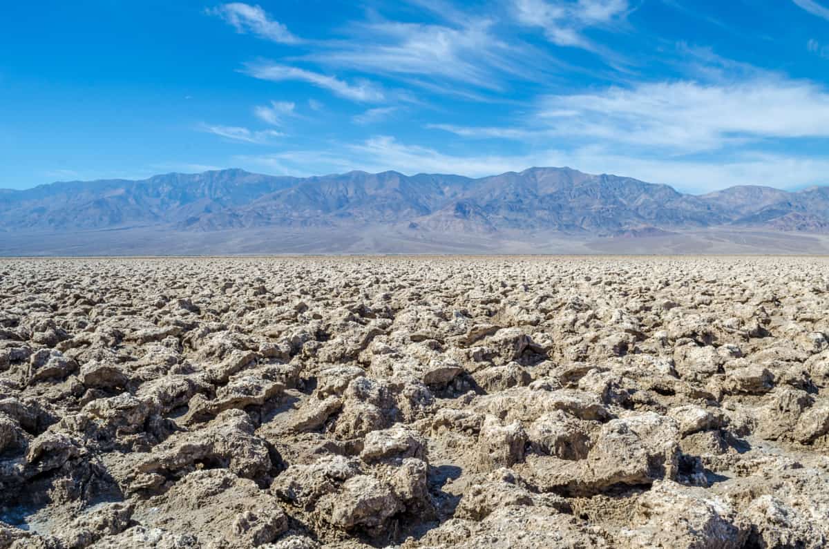
Access to the parking area for the Devil’s Golf Course is via a 2.6-mile dirt road off Badwater Road. It was bumpy going in our sedan.
The park recommends viewing the salt formations from the parking lot to protect the area.
Plus, walking around on the jagged surface can cause injury. Some of the spires stick out a couple of feet above the ground! Make sure you are wearing sturdy, closed-toed shoes if you step out.
If it’s quiet and you strain your ears, you can hear the salt crystals ping as they expand and contract.
7. Step Inside the Furnace Creek Visitor Center
The mid-century modern Furnace Creek Visitor Center is located along California SR190 in the heart of the park, near Badwater Road.
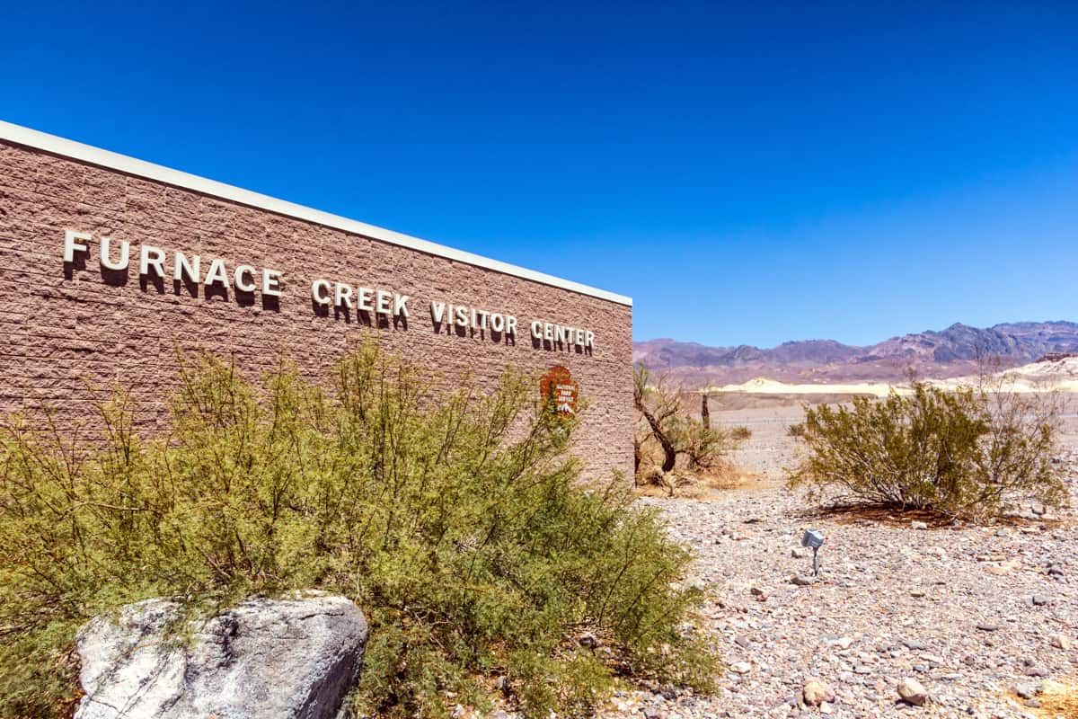
Step into the Visitor Center to learn more about Death Valley National Park and to get your questions answered by a ranger. You can watch a 20-minute film about the park and view the exhibits.
If you are planning to hike in the park, or bike or drive on unpaved roads, or visit some of the more remote Death Valley attractions, you may want to discuss your plans with a ranger and get advice and suggestions.
Also, find out what ranger-led programs are being offered during your time in the park. Joining a ranger-led walk or other activity can exponentially enhance your experience!
There’s a bookstore to browse, and you can also pose for a photo by the Furnace Creek thermometer!
8. Hike to the Natural Bridge
The Natural Bridge Trail is a 2-mile round trip hike that leads to a natural arch and some dry falls.
It is one of the easiest canyon hikes in Death Valley, perfect if you just want to stretch your legs or if you are traveling with young kids.
There is an initial uphill stretch on a gravelly trail, but the rest of the walk is pretty level. Unless you visit at mid-day, you will even have shade once you enter the canyon.
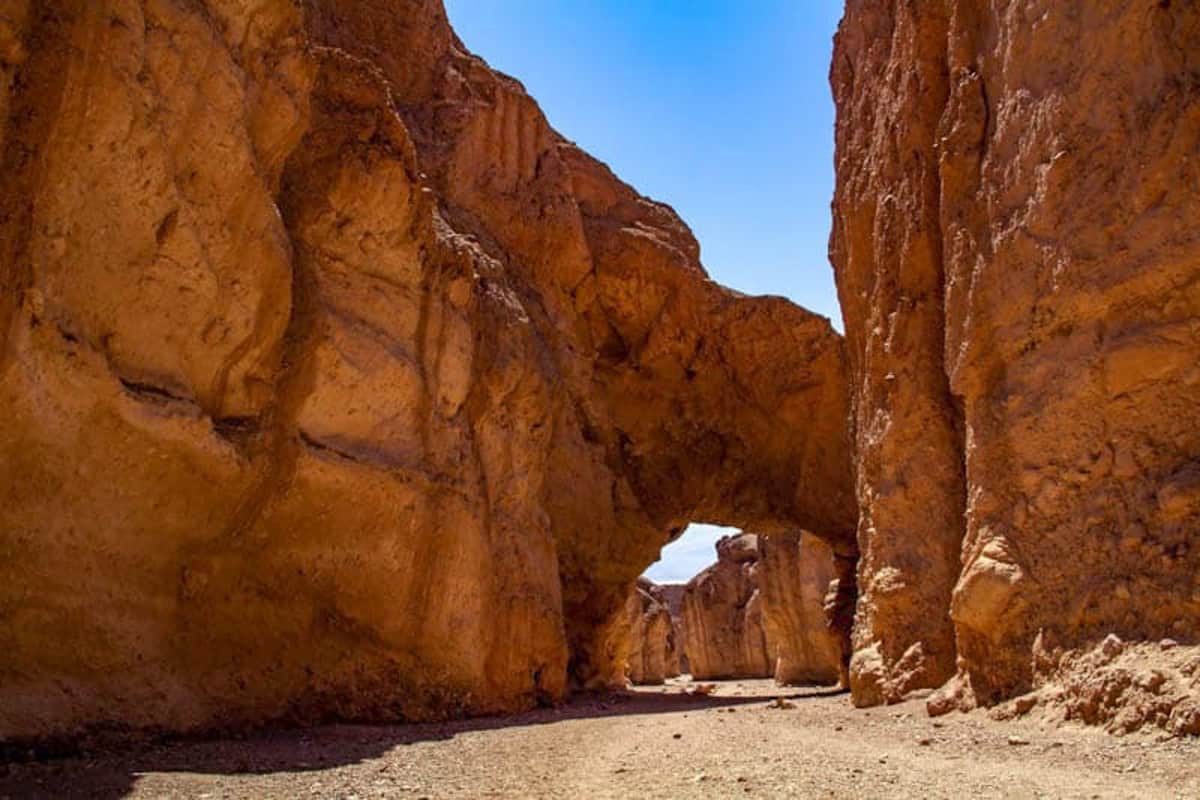
The bridge comes up about 0.5 mile from the trailhead, but it’s worth going beyond to see the rock formations and the dry falls, if you are okay with a little rock scrambling towards the end.
Carved by flash floods through the years, Natural Arch is not smooth rock but a cement of rock and sediment.
Pro Tip: Make sure you take photos of the bridge from both directions!
On the way back out, enjoy beautiful views of the salt flats and the mountains in the distance. Visit in the morning or evening for shade.
The trailhead is located off Badwater Road, about 13.5 miles from the junction of Highway 190 and Badwater Road.
Word of warning. The 1.5-mile dirt road to the trailhead was extremely rough and bumpy when we visited. We made it to the trailhead and back in a sedan, but it was not fun.
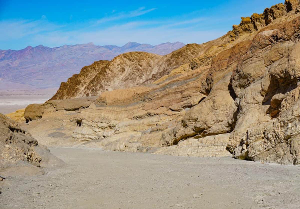
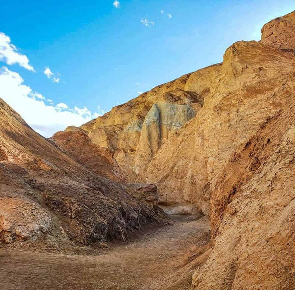
9. Drive through the Twenty Mule Team Canyon
Featuring beautiful views of eroded badlands, the 2.5-mile one-way drive through the Twenty Mule Team Canyon is extremely picturesque.
The road is a dirt road listed as suitable for most vehicles. We did it in our sedan with no issues, but remember to check road conditions before you begin your drive.
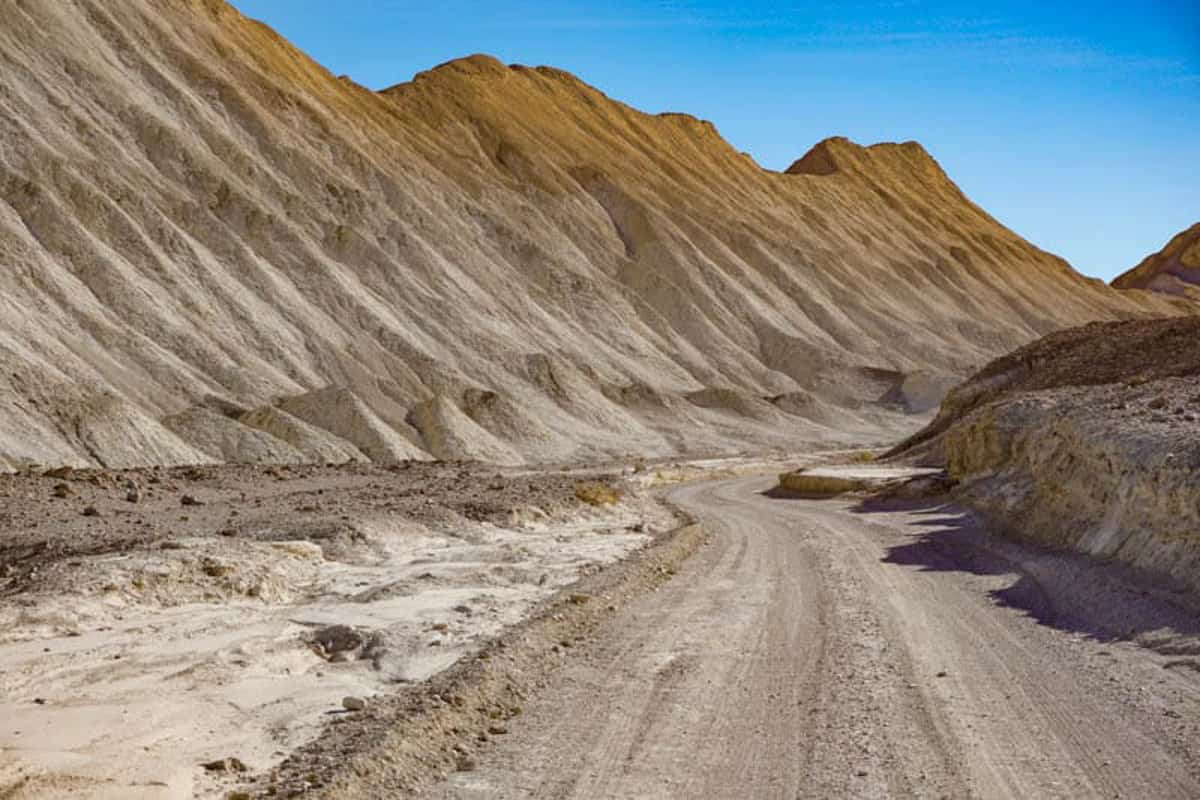
The colorful badlands look even more beautiful in the mellow light of early morning or late afternoon.
If the weather is nice, you can stop at a couple of places along the drive to explore nearby hills and ravines. Be careful to park well off the road.
Although the canyon is named for the twenty mule teams that transported borax out of the valley, they reportedly didn’t travel through this particular canyon.
Look for colorful mineral deposits on the hills: although not quite as bright as Artist’s Palette, they still look beautiful.
The entrance to Twenty Mule Team Canyon comes up along Highway 190, a little southeast of Zabriskie Point.
10. Hike the Golden Canyon Trail
If you only have time for one moderately long hike on your visit, make it the Golden Canyon-Gower Gulch loop trail. It is a popular hike, so you might want to do it early or late in the day, at which times the light will be nicer as well.
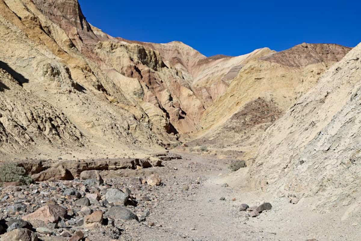
The 4-mile loop is relatively flat, and takes you through some of the most scenic parts of the badlands you see from Zabriskie Point.
You start by walking up the Golden Canyon towards Manly Beacon. Here you can choose to do an extra spur to the Red Cathedral and back.
You then follow the wash down to Gower Gulch, passing the remnants of old borax mines. Follow the trail out of the canyon and across the desert back to the parking lot.
Seeing the colorful badlands landscape up close is a treat. The Golden Canyon hike is perfect if you are visiting Death Valley National park for the first time.
Check to see if it’s being offered as a ranger-led hike when you visit: we learned a lot by doing it as a guided hike.
If you want to do a shorter hike, walk into the Golden Canyon and back. Or hike the Badlands Loop, which starts from Zabriskie Point.
11. Peek into the Past at Harmony Borax Works
If you enjoy history, walk the short interpretive trail at Harmony Borax Works, located near the Furnace Creek Visitor Center along the main road.
Borax was found in the area in 1881, and the Harmony Borax plant started processing borax ore in 1883.
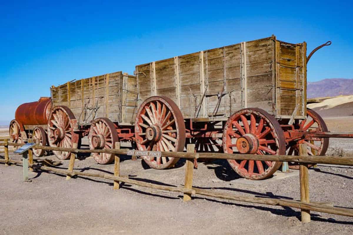
To haul the ore out of Death Valley, double wagons drawn by teams of twenty mules (or horses) were used.
You can see a red double wagon at Harmony Borax Works when you visit, and other equipment at the Borax Museum near The Ranch at Death Valley.
The Harmony plant stopped processing after just five years, because its owner went bankrupt.
In 1974, Harmony Borax Works was placed on the National Register of Historic Places.
12. Stroll the Salt Creek Interpretive Trail
A 0.5-mile accessible boardwalk loop trail, the Salt Creek Interpretive Trail is a draw because the creek contains a species of pupfish, tiny little blue fish that dart in and out of vegetation by the side of the water.
Salt Creek is also a prime birding location, so bring your binoculars!
While Salt Creek is usually dry in the warmer months, you’ll likely see water here in the winter.
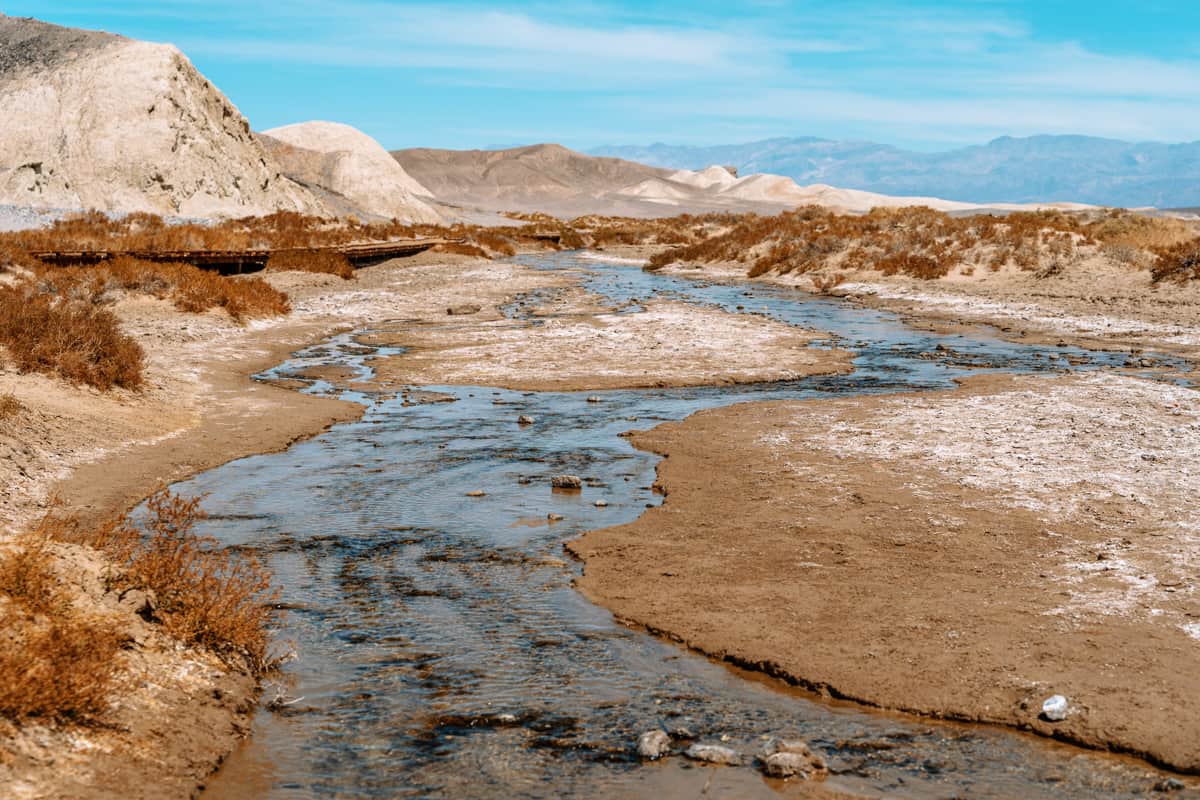
The trail is accessed via a dirt road that is described as generally appropriate for sedans. We found all the dirt roads we tried in the park somewhat bumpier than expected.
The best time to do this trail is in the spring, when the pupfish are in spawn, but you may see them at other times of year as well.
Wear bug spray: you may encounter biting flies, especially in warm weather.
13. Hike the Cool Mosaic Canyon
Mosaic Canyon is one of our favorite hikes in Death Valley National Park. The trailhead is accessed via a 2-mile dirt road near Stovetop Wells, and the 4-mile out and back trail is rated moderately difficult.
The mosaic formations, which are the one of the coolest sights along this trail, come up near the start, so you can walk into the canyon (it’s flat and easy at the start), see the mosaics, and head back out if you choose.
The Mosaic Canyon breccia looks gorgeous, with bits of different types and colors of rock embedded in the natural cement. The marble walls, made of noonday dolomite, are beautiful as well.
About one mile into the canyon, the trail starts to get more difficult, and you have to maneuver past three sets of narrows to reach an amphitheater with a dry falls, which marks the end of the trail.
This handy guide to day hikes in Death Valley National Park comes with a trail map. It’s a great investment if you enjoy hiking: with the hard copy guide and map, you don’t have to worry about not having cellphone reception!
Get it online at REI.
14. Gawk at the Enormous Ubehebe Crater
Located in the northern part of Death Valley, Ubehebe Crater is magnificent. Less visited because of its distance from other popular sights, Ubehebe Crater is still one of the most stunning places to see in Death Valley if you have the time.
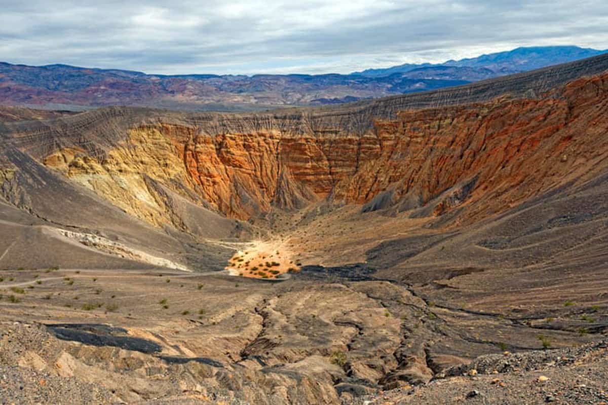
The volcanic crater is 0.5 mile in diameter, and about 600 feet deep. It is a Maar volcano, formed by the explosion of steam and gas, and is believed to have been created only about 300 years ago.
You can simply drive up and view the crater from the parking lot, or you can walk along the rim. Going down into the crater is possible too, but be warned: the climb back up can be extremely demanding!
The rim trail is around 2 miles long, and you’ll see other smaller craters on the route around Ubehebe Crater, including Little Hebe.
If you go counter clockwise, there is an initial climb and then the trail flattens out. Stay on the trail, as the material around the rim is fragile and may give way.
15. See the Strange “Moving” rocks at Racetrack Playa
When we were planning to visit Death Valley for the first time, I researched photo spots in the park and came across the Racetrack and its curious “sailing stones.”
A playa is a dry lake bed, and Racetrack Playa, with its cracked surface, makes for spectacular photos.
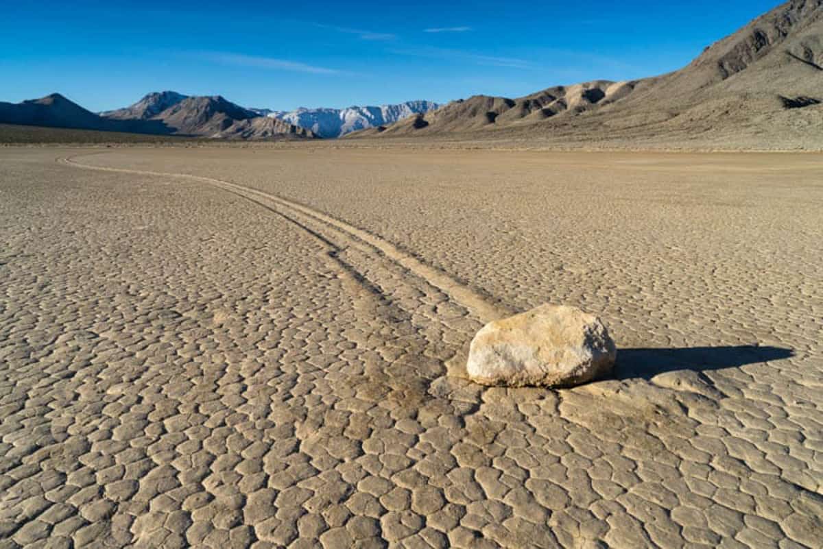
In a mysterious phenomenon, hundreds of rocks, some extremely heavy, appear to have “moved” across the playa, leaving clear tracks for miles.
Scientists have since explained the phenomenon. When the lake bed fills with water in the winter, the water freezes at night.
Warmer weather then causes the ice to melt, and wind carries the sheets of ice around, pushing the rocks with them. Once the ice melts, only the rocks and the mysterious tracks are left!
The road to the Racetrack is extremely rough and bumpy and the location is remote. The park recommends a 4X4 high-clearance vehicle with good tires.
Flat tires are the norm rather than the exception on this drive, and the towing bill is shockingly high. If you are considering it, remember there is no cell phone reception in the park.
16. Take a Photo of Teakettle Junction
Teakettle Junction comes up twenty miles into the drive from Ubehebe Crater to the Racetrack, and is a cool sight to photograph! It’s a quick stop but it has an interesting history.
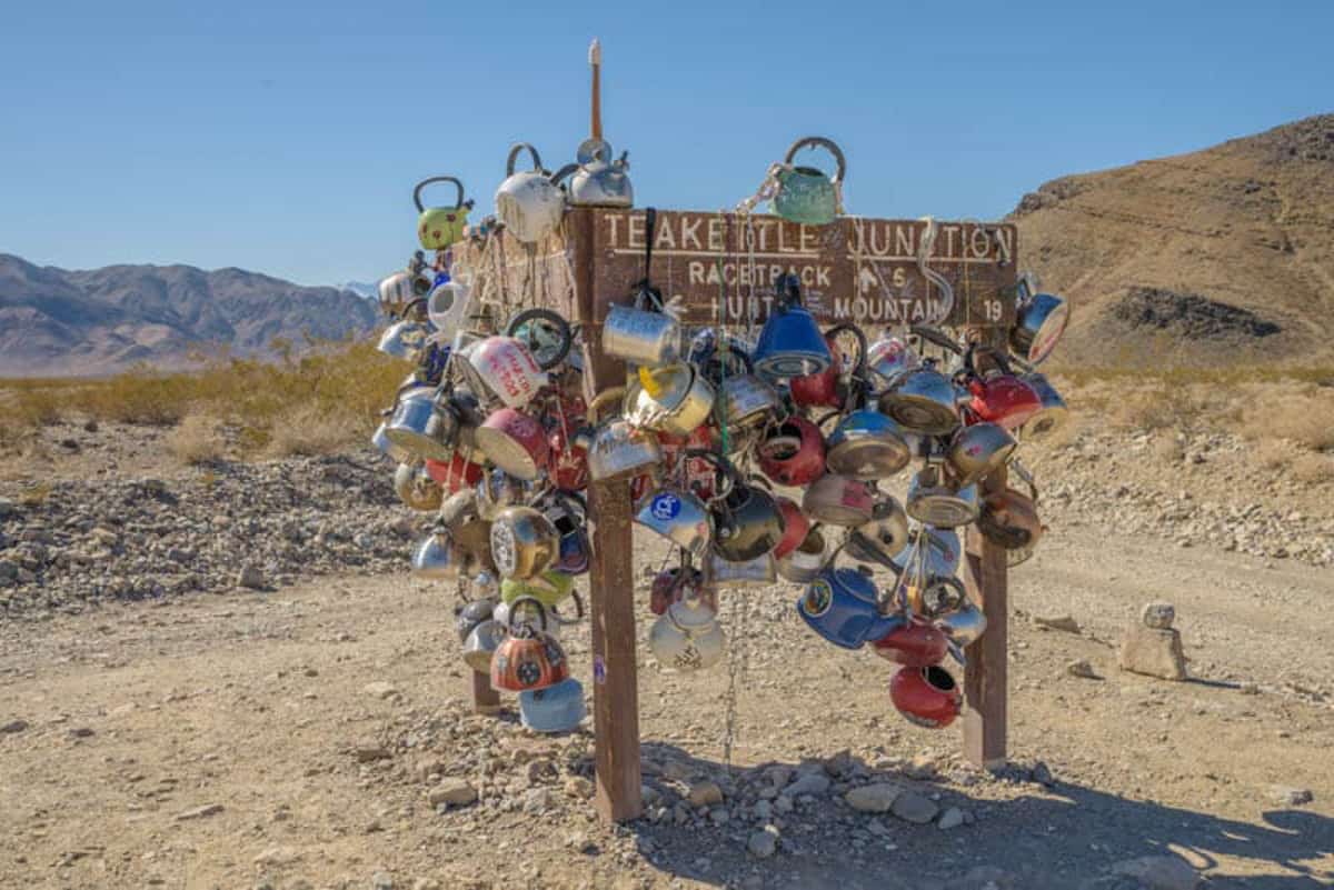
In a strange tradition that started decades ago, travelers to this remote spot started to leave kettles at this junction as markers of their visits.
Today you will see an assortment of kettles of all shapes and sizes here.
Some kettles include messages in different languages, and others contain notes.
According to the tradition, you are supposed to leave a kettle of your own when you visit, and take away one of the existing kettles.
17. Visit Darwin Falls
Did you think you’d find a waterfall in Death Valley National Park?
Darwin Falls is a cascade that plunges into a picturesque green pool, surrounded by lush greenery. Fed by a spring, the waterfall creates a little oasis in the desert that’s Death Valley.
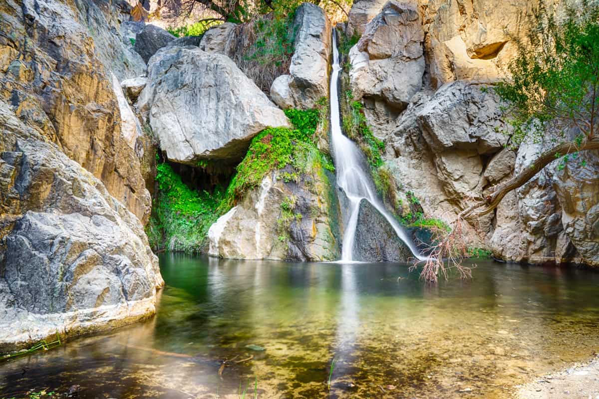
A moderate out-and-back hike of about 2 miles round trip allows you to access this pretty waterfall.
Swimming isn’t allowed, because the water is the drinking water source for Panamint Springs Resort.
There is no marked trail, but there is a worn route. It’s mainly flat, but once you are in the canyon, vegetation across the route and need for stream crossings make the hike challenging at times.
The trailhead is on Darwin Falls Road, off California Highway 190. Darwin Falls Road is supposed to be passable in a sedan, but it can be rocky with lots of potholes. We suggest a high-clearance vehicle.
18. Tour the Wildrose Charcoal Kilns
Located on Emigrant Canyon Road, about 28 miles from California SR 190, the Wildrose Charcoal Kilns are remarkably preserved beehive kilns from the late 19th century, and one of the most interesting historical sights in Death Valley National Park.
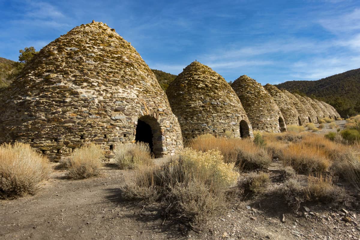
Built by the Modock Consolidate Mining Company to provide fuel in order to smelt ore from nearby mines, the kilns operated for only three or four years.
The last couple of miles of road leading to the Wildrose Charcoal Kilns are gravel, but typically passable in a sedan.
You can view the structures from the parking area, or get out to explore. Wear sturdy closed-toed shoes as the terrain is not even.
19. Recall Tatooine from Star Wars at Desolation Canyon
Desolation Canyon in Death Valley National Park is one of the locations where a couple of episodes of Star Wars were filmed some decades ago. Hike the canyon to see if you can recognize Tatooine!
The Desolation Canyon Trail is 3.6 miles out and back, and rated moderate to difficult. Attempt this hike only in the cooler months of the year. A 3.7-mile gravel road generally passable to sedans leads from Badwater Road to the trailhead.
The cross country hike is unmarked, but you can follow the wash towards the Black Mountains into the canyon. Once you are inside the canyon, you will see colorful deposits on the walls, similar to Artist’s Palette, and interesting geological formations.
The Desolation Canyon hike is very cool, but stay in the main canyon: it’s easy to get lost if you venture into the many side canyons you’ll see along the route!
20. Check out the Keane Wonder Mine
The Keane Wonder Mine operated in the first part of the 20th century, a time when the area was a destination for prospectors that came west to make their fortunes. It is one of the most popular mining sites in Death Valley National Park.
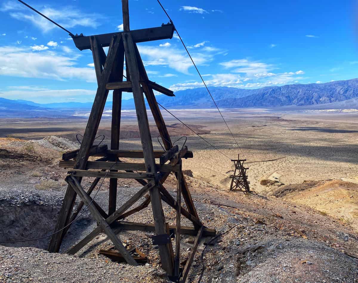
Located near Beatty in the northeast section of the park, the Keane Wonder Mine can only be accessed in a 4WD high clearance vehicle with good tires.
You can walk through the area where the mill was located, and walk a short trail to get a view of the lower tram terminal and some of the towers. You can see the ore buckets that were used to transport the gold ore all those years ago.
If you are up for a steep climb, hike the 1.4-mile trail in the Funeral Mountains to the upper tram terminal and the mine. Pay heed to signs that warn you to stay away from known mine openings. Keep an eye out for wildlife!
21. Do Some Stargazing
As a Gold Tier Dark Sky National Park, Death Valley offers some of the best stargazing and astrophotography opportunities in the country.
While you can enjoy stargazing and photographing the night sky year round, the park holds special dark sky events in the winter and the spring. A clear, no-moon night offers the best stargazing conditions.
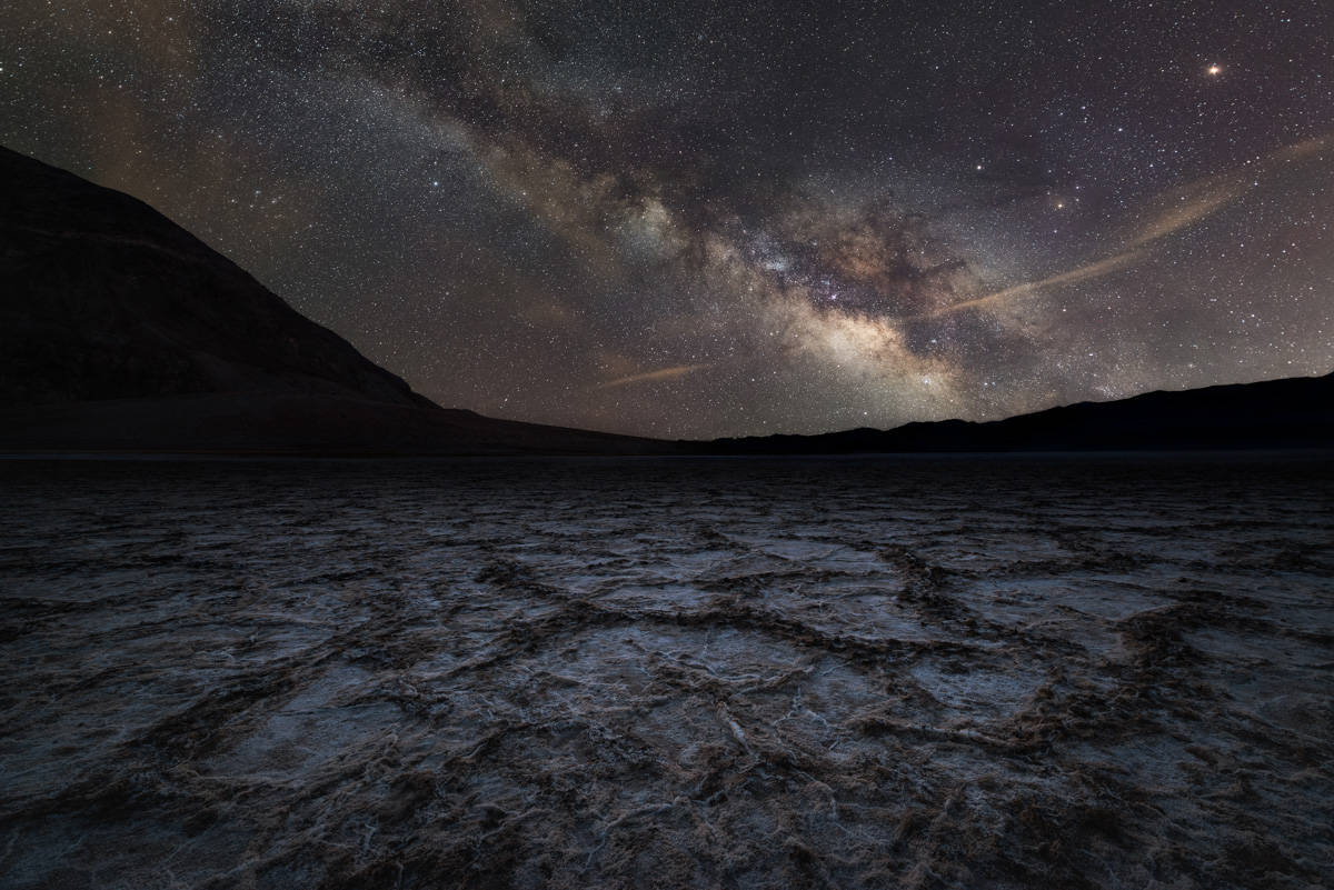
Some of the best areas in the park for stargazing include Harmony Borax Works and Ubehebe Crater.
Mesquite Flat Sand Dunes is another popular stargazing spot, although you might get some light pollution. Badwater Basin is another great spot.
Bring binoculars to get a closer look, and remember to come prepared to stay out for a while, since it takes your eyes time to get adjusted to the dark.
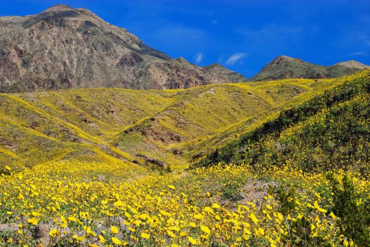
22. Enjoy Wildflowers in Spring
If you visit Death Valley National Park in the spring of a superbloom year, you’ll be treated to expansive carpets of yellow, white, pink, and purple as wildflowers put on a spectacular show.
Superbloom years aren’t frequent, so it’s worthwhile making the effort to visit when you read that such a bloom is in the offing.
In other years, although bloom may not be as prolific, you will still see wildflowers in the spring.
At the lower elevations of the park, expect to see blooms between mid to late February and mid April. At higher elevations, bloom occurs later and may last until mid July.
Desert gold, phacelia, mariposa lily, sage, and lupine, are some of the flowers that bloom at varying elevations in the park.
Where to Stay in Death Valley National Park
If you are looking to stay inside Death Valley National Park (which is the wise thing to do if you want to maximize your sightseeing time in the park), and you don’t want to camp, there are three hotels from which to pick.
The Inn at Death Valley is a beautiful historic inn housed in a Spanish Colonial Revival style building right off California SR 190 at Furnace Creek. You can pick from rooms in the main building or standalone casitas. Featuring a pool and terraces with beautiful views, the Inn at Death Valley is a fabulous choice!
Book a stay here
The Ranch at Death Valley is a slightly more modest option, also located at Furnace Creek. With on-site dining, comfortable rooms, and a pool, the Ranch is a great choice. We stayed here on one of our visits to the park and loved our room and the convenience of being inside the park.
Book a stay here
The Stovetop Wells Village Hotel is a rustic western style hotel with an on-site restaurant and saloon. Rooms are comfortable and some rooms feature views of the Mesquite Flat sand dunes.
Read reviews on Tripadvisor
There are several campgrounds in Death Valley, of course, and many allow RVs, including the Furnace Creek Campground and the RV park at Stovepipe Wells.
If you don’t own an RV, but you are considering renting one for your visit to Death Valley, check out Outdoorsy to find the perfect vehicle for your trip!
Read Next
The Best Places to stay in Death Valley
*****
Planning to explore more of California’s natural beauty? Check out our articles on other national parks in California!
- Pinnacles National Park: The Ultimate Guide
- Things to Do in Redwood National and State Parks
- Things to Do in Joshua Tree National Park
- Things to Do in Lassen Volcanic National Park
- Things to Do in Sequoia National Park
Did you find this article informative? Pin it for later reference!

This information about Death Valley is excellent, especially with the map. I feel ready to go in a few weeks, thanks to all your tips.
It is a beautiful park, and winter and early spring are wonderful from a weather perspective. Have fun!